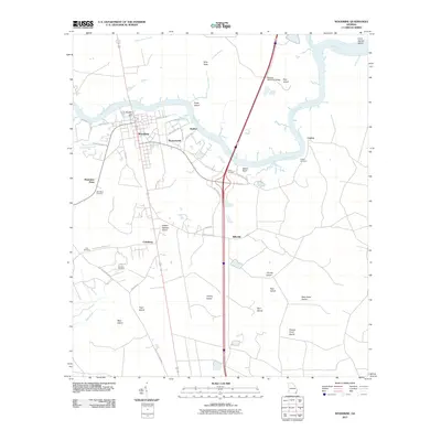
2011 Map of Woodbine
USGS Topo · Published 2011About this map
The Satilla River winds through this coastal Georgia landscape, serving as a historic arterial waterway for the riverside settlements of Woodbine, Satilla Bluff, and Ceylon. This 2011 survey captures the area at a time of modern connectivity via the Kenneth McCarthy Bridge, yet the map preserves traces of earlier settlement patterns through numerous family-named burial sites. Genealogy researchers can find locations for the Cole Cemetery, Whitaker Cemetery, and Green Cemetery, which are scattered among the tidal islands and lowlands. The terrain is characterized by a complex network of marshes and named landmasses like Walker Swamp Island and Tiger Island, illustrating the delta-like environment where White Oak Creek and Piney Island Creek meet the main river channel. Small residential pockets like Billyville and Runnymeade remain tucked between the river's bends and the primary road corridors.
Find a feature on this map
52 named features on this map. Tap any name to fly to it.
Don’t see what you’re looking for? This feature index may not catch every label — zoom into the map to look around manually.
Map Details
Editions of this 2011 Woodbine Map
This is the sole edition of this map. No revisions or reprints were ever made.
Other maps of this area

1917 · Nahunta
USGS Topo · 1:62,500

1917 · Boulogne
USGS Topo · 1:62,500

1918 · Nahunta
USGS Topo · 1:62,500

1918 · Bladen
USGS Topo · 1:62,500

1918 · Kingsland
USGS Topo · 1:62,500

1919 · Boulogne
USGS Topo · 1:62,500

1939 · Bladen
USGS Topo · 1:62,500

1946 · Brunswick
USGS Topo · 1:250,000

1948 · Jacksonville
USGS Topo · 1:250,000

1948 · Brunswick
USGS Topo · 1:250,000