1995 Map of Woodmansie
USGS Topo · Published 1998About this map
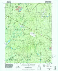
Woodmansie serves as the primary named settlement within this expanse of the New Jersey Pine Barrens, characterized by an extensive network of state-managed lands and specialized agriculture. The map reveals the intricate water management required for regional industry, specifically the numerous Cranberry Bogs and specialized drainage features like Cranberry Bog and Yellow Dam Branch. The terrain is largely preserved through a contiguous series of protected areas including Lebanon State Forest, Penn State Forest, and the Greenwood Forest Wildlife Management Area.
Find a feature on this map
41 named features on this map. Tap any name to fly to it.
Don’t see what you’re looking for? This feature index may not catch every label — zoom into the map to look around manually.
Map Details
Editions of this 1995 Woodmansie Map
This is the sole edition of this map. No revisions or reprints were ever made.
Other maps of this area

1884 · Whitings
USGS Topo · 1:62,500

1888 · Pemberton
USGS Topo · 1:62,500

1888 · Little Egg Harbor
USGS Topo · 1:62,500

1888 · Whitings
USGS Topo · 1:62,500

1890 · Mullica
USGS Topo · 1:62,500

1893 · Little Egg Harbor
USGS Topo · 1:62,500

1894 · Pemberton
USGS Topo · 1:62,500

1894 · Mullica
USGS Topo · 1:62,500

1898 · Pemberton
USGS Topo · 1:62,500

1898 · Mullica
USGS Topo · 1:62,500
Featured Places
- Manchester Township, NJ
- Stafford Township, NJ
- Lacey Township, NJ
- Barnegat Township, NJ
- Little Egg Harbor Township, NJ