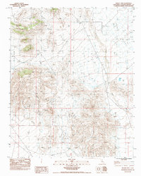
1983 Map of Woods Mtn
USGS Topo · Published 1983About this map
The Woods Mountains dominate this 1980s landscape in San Bernardino County, where the high desert terrain reveals a network of ephemeral drainage systems and distinctive geological formations. Evidence of human activity is sparse but telling, marked by the solitary Watson Well and a prospect site near Table Top. The map captures the complex topography between Lanfair Valley and Round Valley, punctuated by landmarks like Tortoise Shell Mountain and Twin Buttes. This survey documents a period of remote land management, illustrating how desert washes such as Woods Wash and Watson Wash define the natural corridors through the volcanic peaks of the Hackberry Mtn area. It is a detailed study of a region defined more by its natural landmarks and water sources than by permanent settlement.
Find a feature on this map
17 named features on this map. Tap any name to fly to it.
Don’t see what you’re looking for? This feature index may not catch every label — zoom into the map to look around manually.
Map Details
Editions of this 1983 Woods Mtn Map
This is the sole edition of this map. No revisions or reprints were ever made.
Other maps of this area

1910 · Ivanpah
USGS Topo · 1:250,000

1912 · Ivanpah
USGS Topo · 1:250,000

1942 · Ivanpah
USGS Topo · 1:250,000

1942 · Amboy
USGS Topo · 1:250,000

1943 · Amboy
USGS Topo · 1:250,000

1943 · Fenner
USGS Topo · 1:62,500

1947 · Kingman
USGS Topo · 1:250,000

1948 · Kingman
USGS Topo · 1:250,000

1954 · Needles
USGS Topo · 1:250,000

1954 · Kingman
USGS Topo · 1:250,000