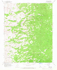
1965 Map of Woody
USGS Topo · Published 1966About this map
Woody Ranch and the small settlement of Gordon define this mid-1960s landscape in Kern County, where the southern Sierra Nevada foothills meet agricultural valleys. The community centers around local landmarks like the Blue Mountain Cem and Blake Sch, reflecting the established rural life of the era. The terrain is deeply carved by a network of seasonal watercourses, including Rag Gulch, Howling Gulch, and Nightingale Gulch, which drain toward the south and west. Connectivity through this hilly region is provided by the Garces Highway and various unimproved paths like the Jeep Trail. Evidence of the area's geological and communication utility is seen in the presence of a Mine near Mt Pheasant and a dedicated Radio Facility. High peaks such as Blue Mountain and Iron Mountain overlook grazing lands and flats like Dog Flat and Poso Flat.
Find a feature on this map
31 named features on this map. Tap any name to fly to it.
Don’t see what you’re looking for? This feature index may not catch every label — zoom into the map to look around manually.
Map Details
Editions of this 1965 Woody Map
2 editions found
Other maps of this area

1906 · Bakersfield
USGS Topo · 1:62,500

1920 · Delonagha
USGS Topo · 1:62,500

1926 · Quincy School
USGS Topo · 1:31,680

1926 · Glennville
USGS Topo · 1:62,500

1929 · Quincy School
USGS Topo · 1:31,680

1932 · Woody
USGS Topo · 1:62,500

1935 · Woody
USGS Topo · 1:62,500

1936 · White River
USGS Topo · 1:62,500

1936 · Tobias Peak
USGS Topo · 1:125,000

1943 · Tobias Peak
USGS Topo · 1:125,000