1934 Map of Worcester
USGS Topo · Published 1934About this map
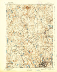
The city of Worcester and its neighboring towns of Holden and West Boylston are captured in this mid-1930s survey, showing a landscape defined by industrial development and institutional expansion. The civic core is densely detailed with landmarks such as the Court House, City Hall, and the Post Office, while the city's academic legacy is represented by the Worcester Polytechnic Institute and the State Teachers College. Rail transit remains central to the region's movement, with the Boston and Maine Railroad serving various points including Jefferson Sta and the bustling Union Sta.
Find a feature on this map
86 named features on this map. Tap any name to fly to it.
Don’t see what you’re looking for? This feature index may not catch every label — zoom into the map to look around manually.
Map Details
Editions of this 1934 Worcester Map
This is the sole edition of this map. No revisions or reprints were ever made.
Historical Maps of Worcester Through Time
4 maps found