
1967 Map of Woronoco
USGS Topo · Published 1978About this map
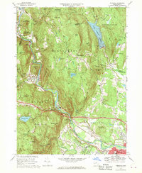
Westfield River carved a deep corridor through these Berkshires foothills, shaping the industrial and transit development of the late 1960s. The village of Woronoco and the industrial activity at Crescent Mills reflect the river-powered economy of this era, while the Penn Central rail lines and the Massachusetts Turnpike track the valley's role as a major east-west transportation artery.
Find a feature on this map
81 named features on this map. Tap any name to fly to it.
Don’t see what you’re looking for? This feature index may not catch every label — zoom into the map to look around manually.
Map Details
Editions of this 1967 Woronoco Map
2 editions found
Other maps of this area

1885 · Northampton
USGS Topo · 1:62,500

1886 · Springfield
USGS Topo · 1:62,500

1886 · Chesterfield
USGS Topo · 1:62,500

1886 · Northampton
USGS Topo · 1:62,500

1887 · Granville
USGS Topo · 1:62,500

1888 · Chesterfield
USGS Topo · 1:62,500

1889 · Springfield
USGS Topo · 1:62,500

1889 · Granville
USGS Topo · 1:62,500

1891 · Northampton
USGS Topo · 1:62,500

1893 · Northampton
USGS Topo · 1:62,500