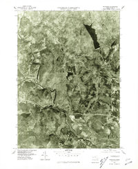
1975 Map of Woronoco
USGS Topo · Published 1981About this map
The Westfield River winds through the hills of Hampden County in the mid-1970s, carving a deep valley that dictates the layout of industry and settlement. This orthophoto mapping provides a literal view of the landscape, where the village of Woronoco sits tightly against the river's bend, historically tied to the paper mills and transport routes that followed the water's edge. To the north, the massive Tighe Carmody Reservoir dominates the higher elevations, while the township of Montgomery spans the upland terrain. The map captures the distinct contrast between the developed river corridors of Russell and Westfield and the dense, wooded tracts of the eastern Berkshires. By using aerial photography, this record shows the exact footprint of forest cover and land use before subsequent decades of suburban expansion and infrastructure changes shifted the character of the valley.
Find a feature on this map
9 named features on this map. Tap any name to fly to it.
Don’t see what you’re looking for? This feature index may not catch every label — zoom into the map to look around manually.
Map Details
Editions of this 1975 Woronoco Map
This is the sole edition of this map. No revisions or reprints were ever made.
Other maps of this area

1885 · Northampton
USGS Topo · 1:62,500

1886 · Springfield
USGS Topo · 1:62,500

1886 · Chesterfield
USGS Topo · 1:62,500

1886 · Northampton
USGS Topo · 1:62,500

1887 · Granville
USGS Topo · 1:62,500

1888 · Chesterfield
USGS Topo · 1:62,500

1889 · Springfield
USGS Topo · 1:62,500

1889 · Granville
USGS Topo · 1:62,500

1891 · Northampton
USGS Topo · 1:62,500

1893 · Northampton
USGS Topo · 1:62,500