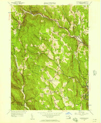
1956 Map of Worthington
USGS Topo · Published 1957About this map
The Middle Branch Westfield River and West Branch Westfield River carve a complex drainage pattern through this section of the Massachusetts Berkshires. Settled upland plateaus and narrow valleys define the landscape, with communities like Worthington Corners and Worthington Center serving as central hubs for a network of rural routes including Stage Road and Windsor Rd. The map illustrates a mid-century transition in land use, where former agricultural tracts are preserved as the Worthington State Forest and Deer Hill State Reservation. Local history is deeply etched into the terrain through family-named landmarks such as Bryant Mtn and Bashan Hill, alongside numerous small burying grounds like Center Cem and Dawes Cem that mark the legacy of the area's earliest residents.
Find a feature on this map
73 named features on this map. Tap any name to fly to it.
Don’t see what you’re looking for? This feature index may not catch every label — zoom into the map to look around manually.
Map Details
Editions of this 1956 Worthington Map
2 editions found
Other maps of this area

1886 · Greylock
USGS Topo · 1:62,500

1886 · Hawley
USGS Topo · 1:62,500

1886 · Chesterfield
USGS Topo · 1:62,500

1886 · Becket
USGS Topo · 1:62,500

1888 · Becket
USGS Topo · 1:62,500

1888 · Chesterfield
USGS Topo · 1:62,500

1890 · Hawley
USGS Topo · 1:62,500

1891 · Greylock
USGS Topo · 1:62,500

1893 · Chesterfield
USGS Topo · 1:62,500

1893 · Becket
USGS Topo · 1:62,500