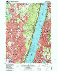
1998 Map of Yonkers
USGS Topo · Published 2000About this map
The Hudson River corridor serves as the dramatic divide between the urbanized hills of Westchester and the suburban landscapes of Bergen County in this late 20th-century survey. On the eastern bank, the dense grid of Yonkers and the Bronx is punctuated by large tracts of preserved land, including the expansive Woodlawn Cemetery and Van Cortlandt Park, home to the Van Cortlandt Mansion House. This area reflects the mature infrastructure of the New York metropolitan region, from the Major Deegan Expwy to the Jerome Park Reservoir.
Find a feature on this map
73 named features on this map. Tap any name to fly to it.
Don’t see what you’re looking for? This feature index may not catch every label — zoom into the map to look around manually.
Map Details
Editions of this 1998 Yonkers Map
This is the sole edition of this map. No revisions or reprints were ever made.
Other maps of this area

1888 · Paterson
USGS Topo · 1:62,500

1891 · Ramapo
USGS Topo · 1:62,500

1891 · Harlem
USGS Topo · 1:62,500

1892 · Paterson
USGS Topo · 1:62,500

1892 · Tarrytown
USGS Topo · 1:62,500

1893 · Tarrytown
USGS Topo · 1:62,500

1893 · Ramapo
USGS Topo · 1:62,500

1897 · Harlem
USGS Topo · 1:62,500

1898 · Harlem
USGS Topo · 1:62,500

1898 · Paterson
USGS Topo · 1:62,500