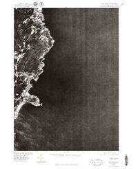
1977 Map of York Beach
USGS Topo · Published 1979About this map
Ogunquit and York Beach sit along this jagged Maine coastline as it appeared in the late 1970s. This orthophotoquad, produced from 1977 aerial imagery by the U.S. Geological Survey and the Soil Conservation Service, provides a detailed photographic record of the residential and commercial development along the shore. The imagery reveals the dense cluster of buildings and roads concentrated at York Beach and the northern settlement of Ogunquit, separated by the rocky inlets and coves that meet the Atlantic Ocean. Because this is an orthophotograph rather than a traditional line-drawn map, it offers a direct look at land use, vegetation patterns, and the exact footprints of coastal properties during this era of Maine's seaside history.
Find a feature on this map
3 named features on this map. Tap any name to fly to it.
Don’t see what you’re looking for? This feature index may not catch every label — zoom into the map to look around manually.
Map Details
Editions of this 1977 York Beach Map
This is the sole edition of this map. No revisions or reprints were ever made.
Other maps of this area

1891 · Biddeford
USGS Topo · 1:62,500

1891 · Kennebunk
USGS Topo · 1:62,500

1893 · Kennebunk
USGS Topo · 1:62,500

1893 · York
USGS Topo · 1:62,500

1893 · Biddeford
USGS Topo · 1:62,500

1898 · Kennebunk
USGS Topo · 1:62,500

1920 · York
USGS Topo · 1:62,500

1941 · Biddeford
USGS Topo · 1:62,500

1941 · Kennebunk
USGS Topo · 1:62,500

1944 · Wells
USGS Topo · 1:24,000