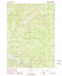
1989 Map of York Butte
USGS Topo · Published 1989About this map
The Illinois National Wild and Scenic River carves through this portion of the Siskiyou National Forest, defining a landscape where industrial history meets protected wilderness. In the late 1980s, this area of Josephine County remains dominated by the steep drainages of North Fork Silver Creek and Briggs Creek. Historical activity is centered on the Old Glory Mine and a Quarry to the south, while former habitations like the Nobles House (Site) and Pine Creek Camp (Site) reflect the region’s older settlement patterns within what is now the Kalmiopsis Wilderness. Significant landmarks such as Silver Falls and York Butte stand as fixed points in a terrain of deep canyons, including Dorr Canyon, where river bars like Panther Bar and Brushy Bar mark the shifting course of the Illinois River.
Find a feature on this map
37 named features on this map. Tap any name to fly to it.
Don’t see what you’re looking for? This feature index may not catch every label — zoom into the map to look around manually.
Map Details
Editions of this 1989 York Butte Map
This is the sole edition of this map. No revisions or reprints were ever made.
Other maps of this area

1917 · Kerby
USGS Topo · 1:125,000

1918 · Kerby
USGS Topo · 1:125,000

1945 · Kerby
USGS Topo · 1:125,000

1946 · Galice
USGS Topo · 1:62,500

1948 · Galice
USGS Topo · 1:62,500

1954 · Marial
USGS Topo · 1:62,500

1954 · Selma
USGS Topo · 1:62,500

1954 · Pearsoll Peak
USGS Topo · 1:62,500

1955 · Medford
USGS Topo · 1:250,000

1957 · Medford
USGS Topo · 1:250,000