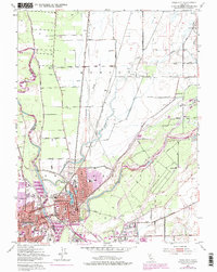
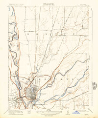
1911 Map of Yuba City
USGS Topo · Published 1911About this map
Marysville and Yuba City sit at the strategic confluence where the Yuba River joins the Feather River, serving as a vital rail and river hub during the early twentieth century. This 1909 survey illustrates a landscape defined by its waterways and complex drainage systems, including Jack Slough, Nigger Slough, and Gilsizer Slough. The heavy influence of the Southern Pacific RR is evident as it cuts through the heart of the settlements, while the surrounding plains of Honcut and New Helvetia are dotted with rural infrastructure. Local education and community life are marked by the positions of Woodruff School, Cordua School, and Linda School. The map also captures early regional transit routes like the Smartsville Road and Bangor Road, which connected these river towns to the interior foothills.
Find a feature on this map
20 named features on this map. Tap any name to fly to it.
Don’t see what you’re looking for? This feature index may not catch every label — zoom into the map to look around manually.
Map Details
Editions of this 1911 Yuba City Map
2 editions found
Historical Maps of Yuba City Through Time
7 maps found