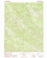
1991 Map of Zeni Ridge
USGS Topo · Published 1991About this map
Habersan Gun Club sits along Larmour Ridge in this mountainous portion of Mendocino County, where the topography is defined by a dense network of ridges and canyon openings. The landscape is marked by unique clearing names such as Little Horse Opening, Big Horse Opening, and Mule Opening, suggesting a history of livestock management or specific trail waypoints. The Garcia River and Rancheria Creek drain the steep terrain, which rises to prominent points like Buck Peak and Dry Bridge Mtn.
Find a feature on this map
40 named features on this map. Tap any name to fly to it.
Don’t see what you’re looking for? This feature index may not catch every label — zoom into the map to look around manually.
Map Details
Editions of this 1991 Zeni Ridge Map
This is the sole edition of this map. No revisions or reprints were ever made.
Other maps of this area

1943 · Point Arena
USGS Topo · 1:62,500

1943 · Boonville
USGS Topo · 1:62,500

1943 · Navarro
USGS Topo · 1:62,500

1943 · Ornbaun
USGS Topo · 1:62,500

1944 · Saddle Point
USGS Topo · 1:62,500

1944 · Ornbaun
USGS Topo · 1:62,500

1947 · Santa Rosa
USGS Topo · 1:250,000

1949 · Santa Rosa
USGS Topo · 1:250,000

1957 · Ukiah
USGS Topo · 1:250,000

1958 · Santa Rosa
USGS Topo · 1:250,000