Old Maps of Pis-Paneu, Chuuk
Explore 2 old maps of Pis-Paneu, spanning from 1997 to today. These high-resolution historic maps reveal how streets, neighborhoods, landmarks, and natural features evolved over time — perfect for genealogy, metal detecting, research, and local history exploration.
What you can do with these maps:
- See how Pis-Paneu changed over time: Compare historical maps to modern-day views to trace roads, homesites, rail lines & more.
- View detailed metadata: Each map includes creators, publishers, year, scale, and archive source.
- Overlay maps with satellite & LiDAR: Visualize the past alongside modern tools to explore terrain & human change.
- Trusted historical sources: Maps sourced from the USGS, Library of Congress, and other archives.
- Access maps your way: View online, download high-res files, or order prints for personal or research use.
Start exploring old maps of Pis-Paneu to uncover forgotten places, hidden landmarks, and the deep history beneath your feet.
Pis-Paneu, TRK maps
(2)- 1997 Map of Piis Moen, 2004 Print
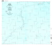 1997 Piis Moen2004 Print · USGSThe northern atolls of the Federated States of Micronesia come into focus in the late nineties, showing the delicate balance of life on the edge of the lagoon. Researchers can trace local settlements from Nukan to Wilton and the maritime passages of Mochonap.
 - 1997 Map of Ruo, 2004 Print
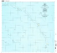 1997 Ruo2004 Print · USGSThe Northeast Islands of Chuuk State appear in fine detail during the late nineties, documenting isolated reef settlements. Genealogists and researchers can trace local island life through locations like Ruo, Sopweru, and the North Bm 2 Ruins.
End of results
Showing maps 1-2 of 2
Frequently asked questions
- What are the different types of historical maps available for Pis-Paneu?
- What is the oldest map of Pis-Paneu?
- Where can I purchase historical maps of Pis-Paneu for my home or office?
- Where can I download high-res historical maps of Pis-Paneu?
- Are there historical topographic maps available for Pis-Paneu?
- Is there historical aerial imagery available for Pis-Paneu?
- Where are historical maps of Pis-Paneu sourced from?