Old Maps of Pis-Paneu, Chuuk for Academic Research
Study the evolution of Pis-Paneu with 2 high-resolution historic maps. Whether you're teaching, researching, or modeling changes in land use, these maps provide essential visual documentation of urban, environmental, and geographic change.
- Analyze long-term change: Track patterns in development, transportation, and natural features.
- Ideal for environmental or urban studies: Support academic projects with primary historical map data.
- Use in the classroom or lab: Educators and researchers rely on these maps to bring historical context to life.
These maps are a powerful tool for teaching, research, and visualizing how Pis-Paneu has changed over the decades.
Pis-Paneu, TRK maps
(2)- 1997 Map of Piis Moen, 2004 Print
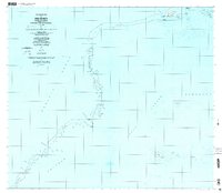 1997 Piis Moen2004 Print · USGSThe northern atolls of the Federated States of Micronesia come into focus in the late nineties, showing the delicate balance of life on the edge of the lagoon. Researchers can trace local settlements from Nukan to Wilton and the maritime passages of Mochonap.
 - 1997 Map of Ruo, 2004 Print
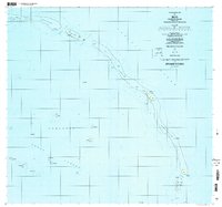 1997 Ruo2004 Print · USGSThe Northeast Islands of Chuuk State appear in fine detail during the late nineties, documenting isolated reef settlements. Genealogists and researchers can trace local island life through locations like Ruo, Sopweru, and the North Bm 2 Ruins.
End of results
Showing maps 1-2 of 2
Frequently asked questions
- What are the different types of historical maps available for Pis-Paneu?
- What is the oldest map of Pis-Paneu?
- Where can I purchase historical maps of Pis-Paneu for my home or office?
- Where can I download high-res historical maps of Pis-Paneu?
- Are there historical topographic maps available for Pis-Paneu?
- Is there historical aerial imagery available for Pis-Paneu?
- Where are historical maps of Pis-Paneu sourced from?