Old Maps of Utwe, Kosrae for Academic Research
Study the evolution of Utwe with 1 high-resolution historic maps. Whether you're teaching, researching, or modeling changes in land use, these maps provide essential visual documentation of urban, environmental, and geographic change.
- Analyze long-term change: Track patterns in development, transportation, and natural features.
- Ideal for environmental or urban studies: Support academic projects with primary historical map data.
- Use in the classroom or lab: Educators and researchers rely on these maps to bring historical context to life.
These maps are a powerful tool for teaching, research, and visualizing how Utwe has changed over the decades.
Utwe, KSA maps
(1)- 2001 Map of Island of Kosrae, 2004 Print
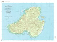 2001 Island of Kosrae2004 Print · USGSMicronesian island life at the start of the twenty-first century is captured here, showing the balance between modern infrastructure and protected wilderness. Researchers can trace coastal villages from Tafunsak to Malem or locate landmarks like Lelu Island and the Walung Elementary School.
End of results
Showing maps 1-1 of 1
Frequently asked questions
- What are the different types of historical maps available for Utwe?
- What is the oldest map of Utwe?
- Where can I purchase historical maps of Utwe for my home or office?
- Where can I download high-res historical maps of Utwe?
- Are there historical topographic maps available for Utwe?
- Is there historical aerial imagery available for Utwe?
- Where are historical maps of Utwe sourced from?