1900s (20th Century) Maps of Northern Mariana Islands
Explore 6 historic maps of Northern Mariana Islands from the 1900s (20th Century). These maps offer a rare glimpse into what life looked like during the 1900s — showing old roads, neighborhoods, homes, and landmarks that have changed or disappeared over time.
Whether you're researching your family's past, planning a metal detecting trip, or studying how Northern Mariana Islands's landscape evolved across the 1900s, these high-resolution maps are a powerful tool for exploring the history of this region.
- Focus on a specific era: All maps on this page are from the 1900s, giving you a focused view of this time period.
- See what’s changed: Compare century-old streets, trails, and buildings to today's modern landscape using overlays and satellite layers.
- Research with precision: Use these maps for genealogy, historical research, land use analysis, or educational projects.
- View, download, or print: Maps are fully viewable online in high resolution, and can be downloaded or printed for your own records.
Start exploring Northern Mariana Islands's history through authentic maps from the 1900s. This is your window into the past.
Northern Mariana Islands maps
(6)- 1983 Map of Island Of Rota (Luta)
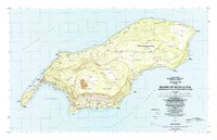 1983 Island Of Rota (Luta)1983 Print · USGSThe Northern Mariana Islands in the early eighties were a landscape of cultural heritage and emerging infrastructure. Researchers can trace indigenous sites like the Latte Stone Quarry alongside settlements such as Songsong and the heights of the Sabana.
 - 1983 Map of Island Of Tinian
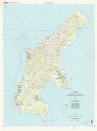
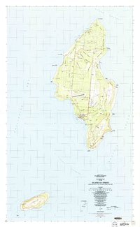 1983 Island Of Tinian1983 Print · USGSTinian in the early eighties remains a landscape deeply marked by its role in the Pacific theater. Researchers can trace the massive footprints of North Field and West Field alongside ancient monuments like the House of Taga and San Jose.
 - 1983 Map of Island Of Saipan
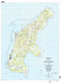 1983 Island Of Saipan1983 Print · USGSSaipan in the early eighties shows a landscape of growing coastal settlements and significant strategic infrastructure. Researchers can trace the development of Garapan, find local Cem sites, and locate the Saipan International Airport.2 unique versions available
 - 1999 Map of Island Of Rota (Luta), 2001 Print
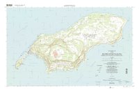 1999 Island Of Rota (Luta)2001 Print · USGSRota's distinctive geography and late-twentieth-century infrastructure are detailed here, from the villages to the high conservation plateaus. Trace the layout of Songsong, find the Rota International Airport, and locate coastal landmarks like As Niebes.
 - 1999 Map of Island Of Saipan, 2001 Print
 1999 Island Of Saipan2001 Print · USGSSaipan near the end of the century shows a sophisticated Pacific hub of modern infrastructure and residential growth. Researchers can trace the development of coastal villages like Garapan and Chalan Kanoa, or locate the Historical Landmark at Puntan Sabaneta.
 - 1999 Map of Island Of Tinian, 2001 Print
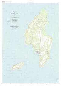 1999 Island Of Tinian2001 Print · USGSTinian and the neighboring islet of Aguijan appear here at the close of the twentieth century, showing the intersection of military history and local growth. Researchers can trace the layout of the North Field Military Reservation and find local landmarks like the Leprosarium or the village of San Jose.
End of results
Showing maps 1-6 of 6
Top regions of Northern Mariana Islands
Top cities of Northern Mariana Islands
Frequently asked questions
- What are the different types of historical maps available for Northern Mariana Islands?
- What is the oldest map of Northern Mariana Islands?
- Where can I purchase historical maps of Northern Mariana Islands for my home or office?
- Where can I download high-res historical maps of Northern Mariana Islands?
- Are there historical topographic maps available for Northern Mariana Islands?
- Is there historical aerial imagery available for Northern Mariana Islands?
- Where are historical maps of Northern Mariana Islands sourced from?