Old Maps of Tachok (Teneto), Songsong for Hiking & Exploration
Hike through history with 2 historic maps of Tachok (Teneto). Explore old trails, ghost towns, and forgotten backroads — perfect for outdoor adventurers and local explorers.
- Rediscover forgotten places: Map out old mining camps, roads, and footpaths that no longer exist on modern maps.
- Layer with modern tools: Combine with LiDAR or satellite views to plan hikes through historical terrain.
- Made for exploration: Popular among hikers, overlanders, and local history lovers.
Use these maps to find adventure and explore the hidden past of Tachok (Teneto).
Tachok (Teneto), Songsong maps
(2)- 1983 Map of Island Of Rota (Luta)
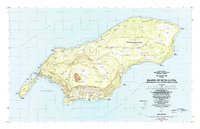 1983 Island Of Rota (Luta)1983 Print · USGSThe Northern Mariana Islands in the early eighties were a landscape of cultural heritage and emerging infrastructure. Researchers can trace indigenous sites like the Latte Stone Quarry alongside settlements such as Songsong and the heights of the Sabana.
 - 1999 Map of Island Of Rota (Luta), 2001 Print
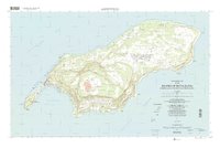 1999 Island Of Rota (Luta)2001 Print · USGSRota's distinctive geography and late-twentieth-century infrastructure are detailed here, from the villages to the high conservation plateaus. Trace the layout of Songsong, find the Rota International Airport, and locate coastal landmarks like As Niebes.
End of results
Showing maps 1-2 of 2
Frequently asked questions
- What are the different types of historical maps available for Tachok (Teneto)?
- What is the oldest map of Tachok (Teneto)?
- Where can I purchase historical maps of Tachok (Teneto) for my home or office?
- Where can I download high-res historical maps of Tachok (Teneto)?
- Are there historical topographic maps available for Tachok (Teneto)?
- Is there historical aerial imagery available for Tachok (Teneto)?
- Where are historical maps of Tachok (Teneto) sourced from?