Old Maps of Sumidero, Aguas Buenas for Genealogy
Trace your family roots with 16 historic maps of Sumidero. These high-res maps reveal old neighborhoods, homesites, landmarks, and streets — helping you uncover where your ancestors lived and how the area evolved over time.
- Explore historic neighborhoods: Identify where your relatives may have lived in the 1800s or 1900s.
- Compare maps over time: Trace the changes in streets, buildings, and landmarks for multi-generational research.
- Perfect for genealogy & ancestry research: Used by family historians and researchers to map out lineage and migration.
These maps are an incredible resource for exploring your personal connection to Sumidero's past.
Sumidero, Aguas Buenas maps
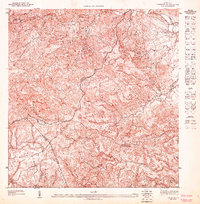
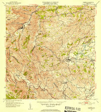
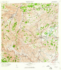
(16)- 1946 Map of Aguas Buenas
 1946 Aguas Buenas1946 Print · USGSCovers Sumidero, including Guaynabo, Trujillo Alto, and other nearby areas3 unique versions available
 - 1946 Map of Comerio
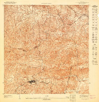
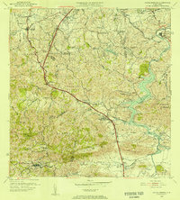
 1946 Comerio1946 Print · USGSCovers Sumidero, including Cidra, Comerío, and other nearby areas3 unique versions available
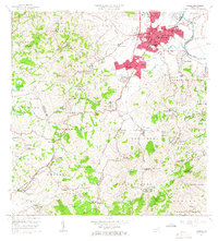
 - 1946 Map of Caguas
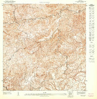
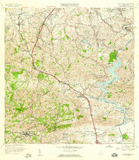
 1946 Caguas1946 Print · USGSCovers Sumidero, including Caguas, Sector Doña Munda, and other nearby areas
 - 1947 Map of Caguas NO
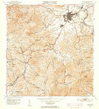
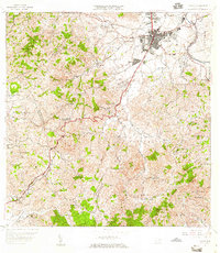
 1947 Caguas NO1947 Print · USGSCovers Sumidero, including Sector Doña Munda, Sector Almena, and other nearby areas
 - 1947 Map of Aguas Buenas SO
 1947 Aguas Buenas SO1947 Print · USGSCovers Sumidero, including Aguas Buenas, Sector Pueblo Santo, and other nearby areas
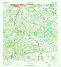
 - 1947 Map of Comerio NE, 1948 Print
 1947 Comerio NE1948 Print · USGSCovers Sumidero, including La Península, Comunidad Los Delgado, and other nearby areas
 - 1952 Map of Aguas Buenas, 1953 Print
 1952 Aguas Buenas1953 Print · USGSCovers Sumidero, including Guaynabo, Trujillo Alto, and other nearby areas2 unique versions available
 - 1952 Map of Caguas, 1953 Print
 1952 Caguas1953 Print · USGSCovers Sumidero, including Caguas, Sector Doña Munda, and other nearby areas2 unique versions available
 - 1953 Map of Comerio
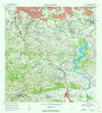
 1953 Comerio1953 Print · USGSCovers Sumidero, including Cidra, Comerío, and other nearby areas
 - 1955 Map of Aguas Buenas, 1956 Print
 1955 Aguas Buenas1956 Print · USGSCovers Sumidero, including Guaynabo, Trujillo Alto, and other nearby areas
 - 1957 Map of Aguas Buenas, 1959 Print
 1957 Aguas Buenas1959 Print · USGSCovers Sumidero, including Guaynabo, Trujillo Alto, and other nearby areas
 - 1957 Map of Caguas, 1959 Print
 1957 Caguas1959 Print · USGSCovers Sumidero, including Caguas, Sector Doña Munda, and other nearby areas
 - 1957 Map of Comerio, 1960 Print
 1957 Comerio1960 Print · USGSCovers Sumidero, including Cidra, Comerío, and other nearby areas5 unique versions available
 - 1964 Map of Caguas, 1966 Print
 1964 Caguas1966 Print · USGSCovers Sumidero, including Caguas, Sector Doña Munda, and other nearby areas4 unique versions available
 - 1964 Map of Aguas Buenas, 1966 Print
 1964 Aguas Buenas1966 Print · USGSCovers Sumidero, including Guaynabo, Trujillo Alto, and other nearby areas
 - 1969 Map of Aguas Buenas, 1972 Print
 1969 Aguas Buenas1972 Print · USGSCovers Sumidero, including Guaynabo, Trujillo Alto, and other nearby areas4 unique versions available
End of results
Showing maps 1-16 of 16
Frequently asked questions
- What are the different types of historical maps available for Sumidero?
- What is the oldest map of Sumidero?
- Where can I purchase historical maps of Sumidero for my home or office?
- Where can I download high-res historical maps of Sumidero?
- Are there historical topographic maps available for Sumidero?
- Is there historical aerial imagery available for Sumidero?
- Where are historical maps of Sumidero sourced from?