1940s Maps of Ceiba
Explore 7 historic maps of Ceiba from the 1940s. These maps offer a rare glimpse into what life looked like during the 1940s — showing old roads, neighborhoods, homes, and landmarks that have changed or disappeared over time.
Whether you're researching your family's past, planning a metal detecting trip, or studying how Ceiba's landscape evolved across the 1940s, these high-resolution maps are a powerful tool for exploring the history of this region.
- Focus on a specific era: All maps on this page are from the 1940s, giving you a focused view of this time period.
- See what’s changed: Compare century-old streets, trails, and buildings to today's modern landscape using overlays and satellite layers.
- Research with precision: Use these maps for genealogy, historical research, land use analysis, or educational projects.
- View, download, or print: Maps are fully viewable online in high resolution, and can be downloaded or printed for your own records.
Start exploring Ceiba's history through authentic maps from the 1940s. This is your window into the past.
Ceiba maps
(7)- 1945 Map of El Yunque
 1945 El Yunque1945 Print · USGSThe peaks of the Luquillo range rise sharply in the mid-1940s, showing the interior of the Caribbean National Forest before modern expansion. Genealogists and historians can trace old community sites like Mameyes (Palmer), the Escuela Casiano Cepeda, and the localized activity at La Mina.
 - 1946 Map of El Yunque
 1946 El Yunque1946 Print · USGSNortheastern Puerto Rico is depicted here in the mid-1940s, showcasing the mountainous interior as it rises from the coast. Researchers can trace the trails and summits of the Luquillo National Forest or locate rural landmarks like Mameyes (Palmer) and the Escuela Casiano Cepeda.3 unique versions available
 - 1946 Map of Punta Puerca
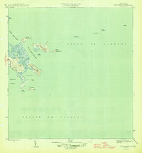 1946 Punta Puerca1946 Print · USGSThe eastern coast of Puerto Rico is shown just after the war, when the Naval Reservation occupied much of the shoreline. Researchers can trace the maritime geography of the Pasaje de Vieques and locate coastal aids like the Faro on Isla Cabras.3 unique versions available
 - 1946 Map of Naguabo
 1946 Naguabo1946 Print · USGSEastern Puerto Rico in the mid-forties reveals a landscape shaped by sugar plantation rail lines and coastal navigation. Genealogists can trace family connections to industrial sites like Colonia San Cristóbal or the coastal village of Shanghai.4 unique versions available
 - 1946 Map of Fajardo
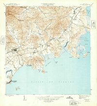
 1946 Fajardo1946 Print · USGSNortheast Puerto Rico is shown just after the war, highlighting a landscape of sugar estates and coastal settlements. Genealogists and historians can trace family locations at Colonia Monserrate, Aldea Cintrón, and the port at Puerto Real.4 unique versions available
 - 1947 Map of El Yunque SE
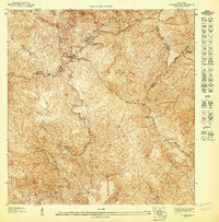 1947 El Yunque SE1947 Print · USGSNaguabo and the surrounding peaks are shown during the late 1940s when the forest was managed under its former name. Trace the early trails and landmarks of the Caribbean National Forest, from the summit of Pico El Yunque to the Area Recreo de la Mina.
 - 1947 Map of Naguabo NE
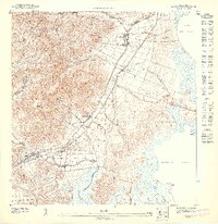 1947 Naguabo NE1947 Print · USGSCoastal eastern Puerto Rico in the late 1940s reveals a landscape defined by sugar production and naval expansion. Trace the rail lines of the Fajardo Development Company through Colonia Aguas Claras or locate early family sites near Daguao and Ceiba.11 unique versions available
End of results
Showing maps 1-7 of 7
Frequently asked questions
- What are the different types of historical maps available for Ceiba?
- What is the oldest map of Ceiba?
- Where can I purchase historical maps of Ceiba for my home or office?
- Where can I download high-res historical maps of Ceiba?
- Are there historical topographic maps available for Ceiba?
- Is there historical aerial imagery available for Ceiba?
- Where are historical maps of Ceiba sourced from?