1900s (20th Century) Maps of Soroco, Fajardo
Explore 3 historic maps of Soroco from the 1900s (20th Century). These maps offer a rare glimpse into what life looked like during the 1900s — showing old roads, neighborhoods, homes, and landmarks that have changed or disappeared over time.
Whether you're researching your family's past, planning a metal detecting trip, or studying how Soroco's landscape evolved across the 1900s, these high-resolution maps are a powerful tool for exploring the history of this region.
- Focus on a specific era: All maps on this page are from the 1900s, giving you a focused view of this time period.
- See what’s changed: Compare century-old streets, trails, and buildings to today's modern landscape using overlays and satellite layers.
- Research with precision: Use these maps for genealogy, historical research, land use analysis, or educational projects.
- View, download, or print: Maps are fully viewable online in high resolution, and can be downloaded or printed for your own records.
Start exploring Soroco's history through authentic maps from the 1900s. This is your window into the past.
Soroco, Fajardo maps
(3)- 1945 Map of Cayo Icacos
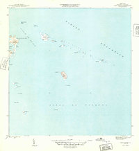 1945 Cayo Icacos1945 Print · USGSThe waters off Fajardo in the mid-1940s reveal a complex archipelago of reefs and keys vital to Caribbean navigation. Maritime researchers can trace the coastal landmarks and tiny islands from Cabezas De San Juan to Isla Palomino and Cayo Icacos.
 - 1952 Map of Cayo Icacos, 1953 Print
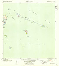 1952 Cayo Icacos1953 Print · USGSThe northeastern coastline of Puerto Rico is mapped here in the early fifties, detailing the reefs and keys of the Fajardo coast. Nautical researchers and historians can locate the Faro de Cabo San Juan and trace the small cays of the Cordillera and Isla Palominos.2 unique versions available
 - 1958 Map of Cayo Icacos, 1960 Print
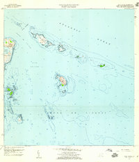 1958 Cayo Icacos1960 Print · USGSThe northeastern coast of Puerto Rico and its offshore cays are captured here in the late fifties, showcasing the area's intricate maritime geography. Researchers can trace the reefs and islands of La Cordillera and locate the iconic Faro de Cabo San Juan and Isla Palominos.4 unique versions available
End of results
Showing maps 1-3 of 3
Frequently asked questions
- What are the different types of historical maps available for Soroco?
- What is the oldest map of Soroco?
- Where can I purchase historical maps of Soroco for my home or office?
- Where can I download high-res historical maps of Soroco?
- Are there historical topographic maps available for Soroco?
- Is there historical aerial imagery available for Soroco?
- Where are historical maps of Soroco sourced from?