1940s Maps of Lajas
Explore 8 historic maps of Lajas from the 1940s. These maps offer a rare glimpse into what life looked like during the 1940s — showing old roads, neighborhoods, homes, and landmarks that have changed or disappeared over time.
Whether you're researching your family's past, planning a metal detecting trip, or studying how Lajas's landscape evolved across the 1940s, these high-resolution maps are a powerful tool for exploring the history of this region.
- Focus on a specific era: All maps on this page are from the 1940s, giving you a focused view of this time period.
- See what’s changed: Compare century-old streets, trails, and buildings to today's modern landscape using overlays and satellite layers.
- Research with precision: Use these maps for genealogy, historical research, land use analysis, or educational projects.
- View, download, or print: Maps are fully viewable online in high resolution, and can be downloaded or printed for your own records.
Start exploring Lajas's history through authentic maps from the 1940s. This is your window into the past.
Lajas maps
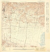
(8)- 1941 Map of San German
 1941 San German1941 Print · USGSThe hills and valleys surrounding San Germán come alive in this early 1940s survey, showing the peak of the railroad era in southwest Puerto Rico. Researchers can trace the American Railroad of Porto Rico through a landscape of historic estates like Hacienda Beatriz Soledad and Hacienda Resolucion.5 unique versions available
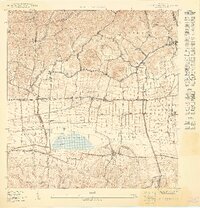
 - 1941 Map of Sabana Grande
 1941 Sabana Grande1941 Print · USGSSouthwest Puerto Rico in the late 1930s shows a landscape of rail-dependent agriculture and highland settlements. Researchers can trace the American Railroad of Porto Rico through stops at Estacion Limon and Fraternidad near the edge of the Laguna de Guanica.5 unique versions available
 - 1949 Map of San German SE
 1949 San German SE1949 Print · USGSThe Lajas Valley in the late 1940s is shown as a thriving agricultural and rail corridor before modern development changed the landscape. Genealogists and historians can trace the American R.R. tracks through Estación Lajas and locate family landmarks like Hacienda Beatriz Soledad.
 - 1949 Map of San German SO
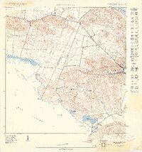
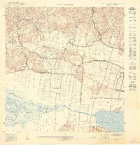
 1949 San German SO1949 Print · USGSSouthwestern Puerto Rico’s agricultural heartland is captured here in the late 1940s, centered on the historic Laguna Cartagena. Researchers can trace the path of the American Railroad of Porto Rico as it served rural estates like Hacienda Desengaño.
 - 1949 Map of Parguera NO
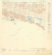
 1949 Parguera NO1949 Print · USGSCoastal Lajas and Cabo Rojo appear here in the late 1940s, highlighting the traditional salt flats and rural landholdings of the southwest shore. Genealogists and historians can locate family landmarks like Rancho Cabassa or trace the geography of Salinas Pitajaya and Isla Guayacán.
 - 1949 Map of Guanica
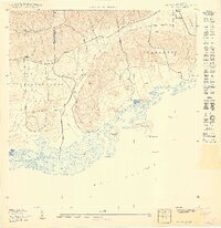
 1949 Guanica1949 Print · USGSCoastal salt production and rural barrios define the southwest shore of Puerto Rico in the late 1940s. Researchers can trace ancestral connections and land use at Salinas Fortuna, Escuela Las Colinas, and the village of Ensenada.
 - 1949 Map of Parguera NE
 1949 Parguera NE1949 Print · USGSThe Lajas coast of southwest Puerto Rico is captured here in the late 1940s, showing the early layouts of coastal settlements and salt flats. Genealogists and historians can locate family sites near Parguera or Papayo and trace landmarks like the Escuela Ramón Baldorioty de Castro.
 - 1949 Map of Sabana Grande SO
 1949 Sabana Grande SO1949 Print · USGSSouthwestern Puerto Rico at mid-century reveals a landscape of industrial rail and coastal wetlands stretching from Lajas toward the Caribbean. Researchers can trace the American Railroad Company line through Estación La Plata and the shores of Laguna de Guánica.
End of results
Showing maps 1-8 of 8
Frequently asked questions
- What are the different types of historical maps available for Lajas?
- What is the oldest map of Lajas?
- Where can I purchase historical maps of Lajas for my home or office?
- Where can I download high-res historical maps of Lajas?
- Are there historical topographic maps available for Lajas?
- Is there historical aerial imagery available for Lajas?
- Where are historical maps of Lajas sourced from?