1940s Maps of Mayagüez
Explore 11 historic maps of Mayagüez from the 1940s. These maps offer a rare glimpse into what life looked like during the 1940s — showing old roads, neighborhoods, homes, and landmarks that have changed or disappeared over time.
Whether you're researching your family's past, planning a metal detecting trip, or studying how Mayagüez's landscape evolved across the 1940s, these high-resolution maps are a powerful tool for exploring the history of this region.
- Focus on a specific era: All maps on this page are from the 1940s, giving you a focused view of this time period.
- See what’s changed: Compare century-old streets, trails, and buildings to today's modern landscape using overlays and satellite layers.
- Research with precision: Use these maps for genealogy, historical research, land use analysis, or educational projects.
- View, download, or print: Maps are fully viewable online in high resolution, and can be downloaded or printed for your own records.
Start exploring Mayagüez's history through authentic maps from the 1940s. This is your window into the past.
Mayagüez maps
(11)- 1941 Map of Rincon
 1941 Rincon1941 Print · USGSCoastal western Puerto Rico in the early 1940s reveals a bustling landscape defined by the sugar industry and the sea. Trace the American Railroad of Puerto Rico as it links Rincón to major mills like Central Igualdad and Central Coloso.
 - 1941 Map of Rincon
 1941 Rincon1941 Print · USGSWestern Puerto Rico’s sugar economy is at its peak in the early 1940s, showing the intricate network of plantations and rails between the coast and the mountains. Genealogists can trace family lands through named estates like Colonia Dolores or follow the American Railroad of Puerto Rico through Añasco.
 - 1941 Map of Rosario, 1952 Print
 1941 Rosario1952 Print · USGSWestern Puerto Rico's mountain interior comes alive in this mid-century survey of the Rosario region. Researchers can trace ancestral lands through numerous named estates like Hacienda Juanita and Hacienda Esperanza, or locate early community centers such as Limon and Iglesia de San Jose.2 unique versions available
 - 1942 Map of Central La Plata
 1942 Central La Plata1942 Print · USGSWestern Puerto Rico during the early 1940s reveals a landscape of sugar production and family estates centered around the Rio Grande de Añasco. Researchers can trace the industrial footprint of Central La Plata and locate traditional plantations such as Hacienda Esperanza and Hacienda Casen.6 unique versions available
 - 1942 Map of Rosario
 1942 Rosario1942 Print · USGSWestern Puerto Rico is captured here in the era before widespread urbanization, showing the mountainous agricultural estates and early rail infrastructure. Genealogists can trace family holdings at Hacienda Esperanza or locate landmarks like the Hospital de Tuberculosis and American R. R.3 unique versions available
 - 1944 Map of Isla Mona, 1963 Print
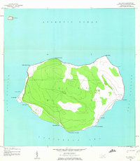 1944 Isla Mona1963 Print · USGSMona Island and its smaller neighbor Isla Monito appear here during the mid-forties, detailing a landscape of coastal cliffs and interior trails. Researchers can locate the Faro, the Aerodromo Emergencia, and landing sites like Anclaje Sardinero.2 unique versions available
 - 1946 Map of Ciales
 1946 Ciales1946 Print · USGSIn the mid-1940s, the mountainous interior between Ciales and Morovis remained a world of coffee estates and remote parishes. Genealogists can locate specific rural landmarks like Hacienda Maria, the Escuela Segunda Unidad de Pesas, and Iglesia San Antonio.3 unique versions available
 - 1947 Map of Rincon
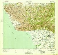
 1947 Rincon1947 Print · USGSCoastal Puerto Rico in the late 1940s reveals a landscape of sugarcane colonies and coastal railways. Researchers can trace family-named sites like Desvío Santoni, the Estación Añasco rail stop, and agricultural hubs like Colonia Libertad.2 unique versions available
 - 1947 Map of Rincon
 1947 Rincon1947 Print · USGSWestern Puerto Rico is captured here in the late 1930s, showing a landscape defined by the coastal sugar economy and the American RR. Genealogists can trace family locations through named colonias like Colonia Libertad and landmarks such as Central Igualdad.
 - 1947 Map of Mayaguez
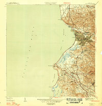 1947 Mayaguez1947 Print · USGSMayagüez and its thriving coastal economy are documented here in the late thirties, featuring the vital rail links of the American Railroad of Puerto Rico. Trace ancestral roots in Poblado Sabalos, Hormigueros, and along the sugar-rich Colonia Cornelia.4 unique versions available
 - 1949 Map of Rincon, 1952 Print
 1949 Rincon1952 Print · USGSWestern Puerto Rico is captured here in the late 1940s, highlighting the intricate network of sugar colonies and railroads. Genealogists can trace family connections to numerous named estates and landmarks like Colonia Libertad, Hacienda Eugenia, and the Pta Jiguera Lighthouse.2 unique versions available
End of results
Showing maps 1-11 of 11
Frequently asked questions
- What are the different types of historical maps available for Mayagüez?
- What is the oldest map of Mayagüez?
- Where can I purchase historical maps of Mayagüez for my home or office?
- Where can I download high-res historical maps of Mayagüez?
- Are there historical topographic maps available for Mayagüez?
- Is there historical aerial imagery available for Mayagüez?
- Where are historical maps of Mayagüez sourced from?