1950s Maps of Ponce
Explore 10 historic maps of Ponce from the 1950s. These maps offer a rare glimpse into what life looked like during the 1950s — showing old roads, neighborhoods, homes, and landmarks that have changed or disappeared over time.
Whether you're researching your family's past, planning a metal detecting trip, or studying how Ponce's landscape evolved across the 1950s, these high-resolution maps are a powerful tool for exploring the history of this region.
- Focus on a specific era: All maps on this page are from the 1950s, giving you a focused view of this time period.
- See what’s changed: Compare century-old streets, trails, and buildings to today's modern landscape using overlays and satellite layers.
- Research with precision: Use these maps for genealogy, historical research, land use analysis, or educational projects.
- View, download, or print: Maps are fully viewable online in high resolution, and can be downloaded or printed for your own records.
Start exploring Ponce's history through authentic maps from the 1950s. This is your window into the past.
Ponce maps
(10)- 1952 Map of Playa De Ponce
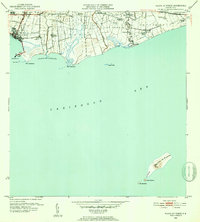 1952 Playa De Ponce1952 Print · USGSThe Puerto Rican coast near Ponce comes alive in the early fifties, showing a landscape of sugar centrales and coastal haciendas. Trace the sugar economy through Central Constancia and find offshore landmarks like the Faro on Isla Caja de Muertos.2 unique versions available
 - 1952 Map of Punta Cuchara
 1952 Punta Cuchara1952 Print · USGSThe southern coast of Puerto Rico appears here at mid-century as a landscape of coastal railroads and colonial estates. Local historians can trace the Porto Rico American Railroad and identify old sites like Hacienda Matilde and Tallaboa Poniente.2 unique versions available
 - 1952 Map of Penuelas, 1953 Print
 1952 Penuelas1953 Print · USGSPeñuelas and the southern foothills of the Cordillera Central are captured here in the early fifties during a period of industrial growth. You can trace the American Railroad of Porto Rico and locate historic estates like Hacienda Oliva and Hacienda Burenes.2 unique versions available
 - 1952 Map of Ponce, 1953 Print
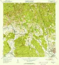
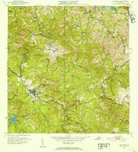
 1952 Ponce1953 Print · USGSThe coastal plains and foothills of southern Puerto Rico appear here during the island's mid-century industrial peak. Researchers can trace the extensive sugar economy through named estates like Hacienda Cristina and the transit lines of the American RR of Puerto Rico.2 unique versions available
 - 1952 Map of Jayuya, 1953 Print
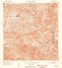 1952 Jayuya1953 Print · USGSThe Cordillera Central mountains surrounding Jayuya appear in high detail during the early fifties, showing the region's dense network of agricultural estates. Genealogists and historians can trace family-named lands like Hacienda Gripiña and Hacienda Santa Rosa near the heights of Cerro de Punta.2 unique versions available
 - 1952 Map of Adjuntas, 1953 Print
 1952 Adjuntas1953 Print · USGSThe mountain municipality of Adjuntas is shown in the mid-fifties amidst its traditional agricultural barrios and coffee-growing haciendas. Genealogists and historians can locate specific family-named estates like Hacienda Artau and Hacienda El Progreso or old parish centers like Iglesia de San Patricio.2 unique versions available
 - 1958 Map of Ponce, 1961 Print
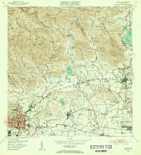
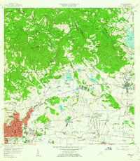 1958 Ponce1961 Print · USGSSouthern Puerto Rico in the late fifties shows the traditional barrios and sugar estates of the coastal plain. Genealogists and historians can locate family lands at Hacienda Luciana, trace the growth of Juana Díaz, or find the Catholic University.
 - 1958 Map of Penuelas, 1961 Print
 1958 Penuelas1961 Print · USGSSouthern Puerto Rico undergoes a mid-century industrial shift as mountain coffee lands meet coastal development. Genealogists and historians can trace family estates like Hacienda Dolores, old parish sites such as Iglesia San Marcus, and early infrastructure from the Refineria De Petroleo.
 - 1958 Map of Playa De Ponce, 1961 Print
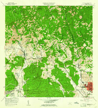
 1958 Playa De Ponce1961 Print · USGSThe southern coast of Puerto Rico is captured here in the late fifties, showcasing the intricate network of riverside haciendas and the bustling waterfront at Playa de Ponce. Genealogists can trace family lands like Hacienda Serrano or locate the historic Faro and the distant Isla Caja de Muertos.
 - 1958 Map of Punta Cucharas, 1961 Print
 1958 Punta Cucharas1961 Print · USGSThe southern coast of Puerto Rico is captured here in the late fifties as the harbor at Playa de Ponce thrived. Researchers can trace the path of the Ferrocarril de Puerto Rico and locate local landmarks like Hacienda Matilde and Cayo Cardona.2 unique versions available
End of results
Showing maps 1-10 of 10
Frequently asked questions
- What are the different types of historical maps available for Ponce?
- What is the oldest map of Ponce?
- Where can I purchase historical maps of Ponce for my home or office?
- Where can I download high-res historical maps of Ponce?
- Are there historical topographic maps available for Ponce?
- Is there historical aerial imagery available for Ponce?
- Where are historical maps of Ponce sourced from?