1900s (20th Century) Maps of Corales del Mar, Salinas
Explore 5 historic maps of Corales del Mar from the 1900s (20th Century). These maps offer a rare glimpse into what life looked like during the 1900s — showing old roads, neighborhoods, homes, and landmarks that have changed or disappeared over time.
Whether you're researching your family's past, planning a metal detecting trip, or studying how Corales del Mar's landscape evolved across the 1900s, these high-resolution maps are a powerful tool for exploring the history of this region.
- Focus on a specific era: All maps on this page are from the 1900s, giving you a focused view of this time period.
- See what’s changed: Compare century-old streets, trails, and buildings to today's modern landscape using overlays and satellite layers.
- Research with precision: Use these maps for genealogy, historical research, land use analysis, or educational projects.
- View, download, or print: Maps are fully viewable online in high resolution, and can be downloaded or printed for your own records.
Start exploring Corales del Mar's history through authentic maps from the 1900s. This is your window into the past.
Corales del Mar, Salinas maps
(5)- 1945 Map of Salinas
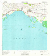
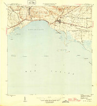 1945 Salinas1945 Print · USGSThe southern coast of Puerto Rico comes alive in this mid-century survey of the sugar-driven economy and maritime geography. Genealogists and historians can trace the legacy of local estates like Hacienda Margarita and the industrial hub at Central Caribe.2 unique versions available
 - 1947 Map of Salinas NE
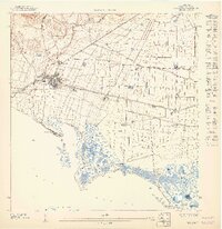 1947 Salinas NE1947 Print · USGSCoastal Puerto Rico's sugar-driven economy is on full display in the 1940s as rail lines and irrigation canals crisscross the plains. Genealogists can locate specific estates like Hacienda Teresa and Colonia Esperanza near the town of Salinas.
 - 1952 Map of Salinas, 1953 Print
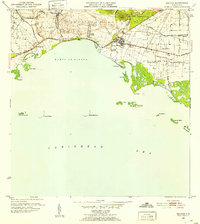 1952 Salinas1953 Print · USGSThe southern coast of Puerto Rico is captured here in the early 1950s, a landscape defined by sugar haciendas and the Caribbean shoreline. Genealogists and historians can locate family-named estates like Hacienda Pales and trace the sugar economy at Central Caribe.2 unique versions available
 - 1960 Map of Salinas, 1962 Print
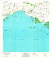 1960 Salinas1962 Print · USGSThe southern coast of Puerto Rico is captured here in the early sixties, showing the agricultural and maritime life of the region. Researchers can trace land holdings like Hacienda Teresa or locate the mid-century Aeropuerto de Salinas.2 unique versions available
 - 1970 Map of Salinas, 1972 Print
 1970 Salinas1972 Print · USGSThe southern coast of Puerto Rico is captured here in the early seventies, detailing the transition from mountain foothills to the Caribbean. Trace historic family estates like Hacienda Carmen or explore coastal features like Mar Negro and the Aeropuerto de Salinas.4 unique versions available
End of results
Showing maps 1-5 of 5
Top cities near Corales del Mar
- Guayama historical maps
- Cayey historical maps
- Coamo historical maps
- Aibonito historical maps
- Juana Díaz historical maps
- Arroyo historical maps
See more
Frequently asked questions
- What are the different types of historical maps available for Corales del Mar?
- What is the oldest map of Corales del Mar?
- Where can I purchase historical maps of Corales del Mar for my home or office?
- Where can I download high-res historical maps of Corales del Mar?
- Are there historical topographic maps available for Corales del Mar?
- Is there historical aerial imagery available for Corales del Mar?
- Where are historical maps of Corales del Mar sourced from?