1900s (20th Century) Maps of Sector Toño Fuentes, San Sebastián
Explore 4 historic maps of Sector Toño Fuentes from the 1900s (20th Century). These maps offer a rare glimpse into what life looked like during the 1900s — showing old roads, neighborhoods, homes, and landmarks that have changed or disappeared over time.
Whether you're researching your family's past, planning a metal detecting trip, or studying how Sector Toño Fuentes's landscape evolved across the 1900s, these high-resolution maps are a powerful tool for exploring the history of this region.
- Focus on a specific era: All maps on this page are from the 1900s, giving you a focused view of this time period.
- See what’s changed: Compare century-old streets, trails, and buildings to today's modern landscape using overlays and satellite layers.
- Research with precision: Use these maps for genealogy, historical research, land use analysis, or educational projects.
- View, download, or print: Maps are fully viewable online in high resolution, and can be downloaded or printed for your own records.
Start exploring Sector Toño Fuentes's history through authentic maps from the 1900s. This is your window into the past.
Sector Toño Fuentes, San Sebastián maps
(4)- 1938 Map of San Sebastian
 1938 San Sebastian1938 Print · USGSSan Sebastian and the surrounding highlands are captured in the late 1930s during a time of rural growth and agricultural production. Researchers can locate dozens of country schools, family estates like Hacienda Buena Vista, and the path of the Central Soller RR.
 - 1941 Map of San Sebastian
 1941 San Sebastian1941 Print · USGSWestern Puerto Rico is captured here in the early 1940s, highlighting the agricultural heartbeat and social centers of the interior. Researchers can trace historic family-named estates like Hacienda San Pedro and Hacienda Espino or locate the industrial Central Soler.5 unique versions available
 - 1950 Map of San Sebastian NE
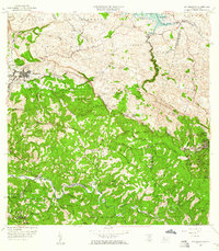
 1950 San Sebastian NE1950 Print · USGSThe northern hills of San Sebastián appear here at mid-century, centered around the industrial and agricultural life of the sugar economy. Researchers can trace the footprint of Central Soller, locate the Campamento Guajataca by the lake, and find local landmarks like Iglesia Santa Ana.
 - 1958 Map of San Sebastian, 1960 Print
 1958 San Sebastian1960 Print · USGSSan Sebastián and the surrounding highlands are captured in the late fifties during a period of industrial and agricultural transition. Researchers can trace ancestral lands through numerous named estates like Hacienda Esperanza or visit the grounds of Central Soller.3 unique versions available
End of results
Showing maps 1-4 of 4
Top cities near Sector Toño Fuentes
- Mayagüez historical maps
- Arecibo historical maps
- Hormigueros historical maps
- Aguadilla historical maps
- Isabela historical maps
- San Sebastián historical maps
See more
Frequently asked questions
- What are the different types of historical maps available for Sector Toño Fuentes?
- What is the oldest map of Sector Toño Fuentes?
- Where can I purchase historical maps of Sector Toño Fuentes for my home or office?
- Where can I download high-res historical maps of Sector Toño Fuentes?
- Are there historical topographic maps available for Sector Toño Fuentes?
- Is there historical aerial imagery available for Sector Toño Fuentes?
- Where are historical maps of Sector Toño Fuentes sourced from?