1940s Maps of Toa Alta
Explore 10 historic maps of Toa Alta from the 1940s. These maps offer a rare glimpse into what life looked like during the 1940s — showing old roads, neighborhoods, homes, and landmarks that have changed or disappeared over time.
Whether you're researching your family's past, planning a metal detecting trip, or studying how Toa Alta's landscape evolved across the 1940s, these high-resolution maps are a powerful tool for exploring the history of this region.
- Focus on a specific era: All maps on this page are from the 1940s, giving you a focused view of this time period.
- See what’s changed: Compare century-old streets, trails, and buildings to today's modern landscape using overlays and satellite layers.
- Research with precision: Use these maps for genealogy, historical research, land use analysis, or educational projects.
- View, download, or print: Maps are fully viewable online in high resolution, and can be downloaded or printed for your own records.
Start exploring Toa Alta's history through authentic maps from the 1940s. This is your window into the past.
Toa Alta maps
(10)- 1940 Map of Vega Alta
 1940 Vega Alta1940 Print · USGSThe northern coast of Puerto Rico was an industrial powerhouse of sugar production and rail transit in the years leading up to the second World War. Genealogists and historians can trace the footprint of the sugar economy through Central Constancia and the American Railroad of Porto Rico.2 unique versions available
 - 1941 Map of Bayamon
 1941 Bayamon1941 Print · USGSBayamón and the northern coast of Puerto Rico appear here in the early 1940s as a landscape of sugar centrales and rail lines. Genealogists and historians can trace family locations through numerous named colonias and landmarks like Central Juanita, Colonia La Monserrate, and Iglesia Cristo Rey.2 unique versions available
 - 1946 Map of Corozal
 1946 Corozal1946 Print · USGSCorozal and the central highlands of Puerto Rico are captured here in the mid-forties, showing a landscape of steep ridges and deep river valleys. Genealogists and local historians can trace the foundations of local education and faith at sites like Escuela Segunda Unidad de Palmarejo and Iglesia La Milagrosa.3 unique versions available
 - 1946 Map of Vega Alta
 1946 Vega Alta1946 Print · USGSCoastal Puerto Rico's sugar-processing heartland is revealed here in the 1940s, showing a complex network of rail lines and industrial centrals. Genealogists and historians can trace old community sites like Poblado Higüillar and family landmarks near Central Carmen.4 unique versions available
 - 1946 Map of Naranjito
 1946 Naranjito1946 Print · USGSNaranjito and the surrounding mountains of central Puerto Rico appear in the mid-1940s as a landscape of agricultural colonias and emerging utilities. Researchers can locate numerous rural chapels like the Iglesia Guadiana and trace the path of the Acueducto de San Juan through the hills.3 unique versions available
 - 1947 Map of Corozal NO
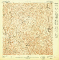 1947 Corozal NO1947 Print · USGSThe Puerto Rican highlands around Corozal are captured in the late 1940s, showing a rural landscape dominated by steep ridges and winding rivers. Researchers can locate specific community institutions such as the Iglesia de la Inmaculada Concepción and the Escuela Segunda Unidad Nicolás Rodríguez Padilla.
 - 1947 Map of Corozal NE
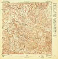 1947 Corozal NE1947 Print · USGSThe north-central highlands of Puerto Rico come alive in this mid-century survey of the interior valleys and ridges. Genealogists and historians can trace the rural landscape surrounding the Escuela Segunda Unidad Quebrada Arenas and the banks of the Río La Plata.
 - 1947 Map of Bayamon
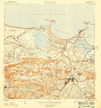 1947 Bayamon1947 Print · USGSBayamon and the San Juan coastline are seen here in the late 1930s as a landscape of sugar central mills and coastal colonies. Researchers can trace the American RR line to Central Juanita or locate old community anchors like Pueblo Viejo and El Cañuelo.4 unique versions available
 - 1947 Map of Naranjito NO
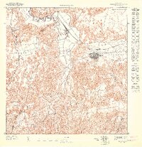
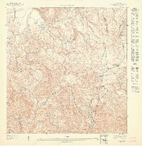 1947 Naranjito NO1947 Print · USGSToa Alta and Naranjito are shown here in the mid-1940s as a patchwork of mountain agriculture and rural faith. Genealogists can trace family footprints near Primera Iglesia de Cristo, the Colonia Piña, and along the winding Rio De La Plata.
 - 1947 Map of Vega Alta SO
 1947 Vega Alta SO1947 Print · USGSVega Alta and its surrounding sugar lands are captured in detail during the mid-1940s. Genealogists and historians can trace the rail lines of the Porto Rico Sugar Company and locate landmarks like Central Carmen and Cerro Miraflores.
End of results
Showing maps 1-10 of 10
Frequently asked questions
- What are the different types of historical maps available for Toa Alta?
- What is the oldest map of Toa Alta?
- Where can I purchase historical maps of Toa Alta for my home or office?
- Where can I download high-res historical maps of Toa Alta?
- Are there historical topographic maps available for Toa Alta?
- Is there historical aerial imagery available for Toa Alta?
- Where are historical maps of Toa Alta sourced from?