Old Maps of Frederiksted Southeast, Saint Croix District for Hiking & Exploration
Hike through history with 5 historic maps of Frederiksted Southeast. Explore old trails, ghost towns, and forgotten backroads — perfect for outdoor adventurers and local explorers.
- Rediscover forgotten places: Map out old mining camps, roads, and footpaths that no longer exist on modern maps.
- Layer with modern tools: Combine with LiDAR or satellite views to plan hikes through historical terrain.
- Made for exploration: Popular among hikers, overlanders, and local history lovers.
Use these maps to find adventure and explore the hidden past of Frederiksted Southeast.
Frederiksted Southeast, Saint Croix District maps
(5)- 1958 Map of Frederiksted, 1960 Print
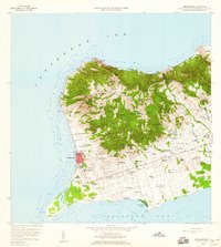 1958 Frederiksted1960 Print · USGSWestern Saint Croix is depicted in the late fifties, showcasing the transition from the waterfront at Frederiksted to inland estates. Trace historic place names and local infrastructure including Betty's Hope, the Fort Frederick Light, and Alexander Hamilton Airport.4 unique versions available
 - 2013 Map of Long Point, 2013 Print
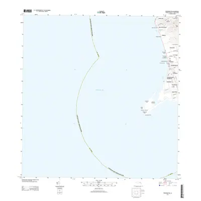
 2013 Long Point2013 Print · USGSCovers Frederiksted Southeast, including Mount Victory, Saint George Hill, and other nearby areas
 - 2013 Map of Frederiksted, 2013 Print
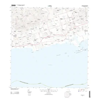
 2013 Frederiksted2013 Print · USGSCovers Frederiksted Southeast, including William, Butler Bay, and other nearby areas
 - 2024 Map of Long Point, 2024 Print
 2024 Long Point2024 Print · USGSThe southern coast of Saint Croix comes into focus in this contemporary survey, showing the island's blend of historic estates and modern infrastructure. Genealogists and researchers can locate landmarks like Friedensfeld Midlands Cem, the Henry E Rohlsen Airport, and Upper Love.
 - 2024 Map of Frederiksted, 2024 Print
 2024 Frederiksted2024 Print · USGSThe west coast of Saint Croix is captured here in the early twenty-first century, centered on the historic port of Frederiksted. Researchers can trace old estate names and civic sites, from Fort Frederick to the Frederiksted Cem and The Whim West.
End of results
Showing maps 1-5 of 5
Top neighborhoods of Frederiksted Southeast
- Frederiksted Southeast historical maps
- Hesselberg historical maps
- Two Brothers historical maps
- Wheel of Fortune historical maps
- Smithfield historical maps
Frequently asked questions
- What are the different types of historical maps available for Frederiksted Southeast?
- What is the oldest map of Frederiksted Southeast?
- Where can I purchase historical maps of Frederiksted Southeast for my home or office?
- Where can I download high-res historical maps of Frederiksted Southeast?
- Are there historical topographic maps available for Frederiksted Southeast?
- Is there historical aerial imagery available for Frederiksted Southeast?
- Where are historical maps of Frederiksted Southeast sourced from?