Old Maps of East End, Saint Thomas - Saint John District
Explore 3 old maps of East End, spanning from 1958 to today. These high-resolution historic maps reveal how streets, neighborhoods, landmarks, and natural features evolved over time — perfect for genealogy, metal detecting, research, and local history exploration.
What you can do with these maps:
- See how East End changed over time: Compare historical maps to modern-day views to trace roads, homesites, rail lines & more.
- View detailed metadata: Each map includes creators, publishers, year, scale, and archive source.
- Overlay maps with satellite & LiDAR: Visualize the past alongside modern tools to explore terrain & human change.
- Trusted historical sources: Maps sourced from the USGS, Library of Congress, and other archives.
- Access maps your way: View online, download high-res files, or order prints for personal or research use.
Start exploring old maps of East End to uncover forgotten places, hidden landmarks, and the deep history beneath your feet.
East End, Saint Thomas - Saint John District maps
(3)- 1958 Map of Eastern St. John, 1959 Print
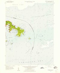 1958 Eastern St. John1959 Print · USGSSt. John's eastern peninsula is captured here in the late fifties, showing the early bounds of the Virgin Islands National Park. Trace the old dirt tracks leading to the settlement at East End or explore the coastlines of Hurricane Hole and Coral Bay.6 unique versions available
 - 2013 Map of Coral Bay, 2013 Print
 2013 Coral Bay2013 Print · USGSCovers East End, including Coral Bay, Coral Harbour, and other nearby areas
 - 2024 Map of Coral Bay, 2024 Print
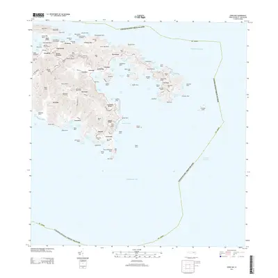
 2024 Coral Bay2024 Print · USGSSaint John’s eastern shores and the protected waters of Coral Bay are documented here in modern detail. Researchers can trace historic land tracts and heritage sites like the Annaberg Sugar Mill, Emmaus Moravian Church Cem, and Fortsberg.
End of results
Showing maps 1-3 of 3
Top cities near East End
Frequently asked questions
- What are the different types of historical maps available for East End?
- What is the oldest map of East End?
- Where can I purchase historical maps of East End for my home or office?
- Where can I download high-res historical maps of East End?
- Are there historical topographic maps available for East End?
- Is there historical aerial imagery available for East End?
- Where are historical maps of East End sourced from?