Old Maps of Fortuna, Saint Thomas - Saint John District
Explore 3 old maps of Fortuna, spanning from 1955 to today. These high-resolution historic maps reveal how streets, neighborhoods, landmarks, and natural features evolved over time — perfect for genealogy, metal detecting, research, and local history exploration.
What you can do with these maps:
- See how Fortuna changed over time: Compare historical maps to modern-day views to trace roads, homesites, rail lines & more.
- View detailed metadata: Each map includes creators, publishers, year, scale, and archive source.
- Overlay maps with satellite & LiDAR: Visualize the past alongside modern tools to explore terrain & human change.
- Trusted historical sources: Maps sourced from the USGS, Library of Congress, and other archives.
- Access maps your way: View online, download high-res files, or order prints for personal or research use.
Start exploring old maps of Fortuna to uncover forgotten places, hidden landmarks, and the deep history beneath your feet.
Fortuna, Saint Thomas - Saint John District maps
(3)- 1955 Map of Western St. Thomas, 1956 Print
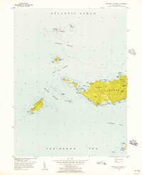 1955 Western St. Thomas1956 Print · USGSWestern St Thomas and its surrounding archipelago are caught in detail during the mid-fifties, showing the island's steep peaks and coastal roads. Trace the island's geography from the heights of Bordeaux Hill down to the unique crossing at the Mermaids Chair or the small settlement at Fortuna.5 unique versions available
 - 2013 Map of Savana Passage, 2013 Print
 2013 Savana Passage2013 Print · USGSCovers Fortuna, including United States Virgin Islands, Saint Thomas - Saint John District, and other nearby areas
 - 2024 Map of Savana Passage, 2024 Print
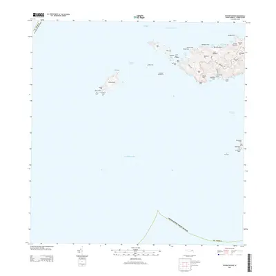
 2024 Savana Passage2024 Print · USGSThe western end of Saint Thomas and its surrounding cays are documented here in detail, showing the modern layout of the islands. Trace the roads and ridges connecting Bordeaux and Fortuna, or explore the isolated coastlines of Savana Island and Botany Bay.
End of results
Showing maps 1-3 of 3
Top cities near Fortuna
Frequently asked questions
- What are the different types of historical maps available for Fortuna?
- What is the oldest map of Fortuna?
- Where can I purchase historical maps of Fortuna for my home or office?
- Where can I download high-res historical maps of Fortuna?
- Are there historical topographic maps available for Fortuna?
- Is there historical aerial imagery available for Fortuna?
- Where are historical maps of Fortuna sourced from?