Old Maps of Fortuna, Saint Thomas - Saint John District for Hiking & Exploration
Hike through history with 3 historic maps of Fortuna. Explore old trails, ghost towns, and forgotten backroads — perfect for outdoor adventurers and local explorers.
- Rediscover forgotten places: Map out old mining camps, roads, and footpaths that no longer exist on modern maps.
- Layer with modern tools: Combine with LiDAR or satellite views to plan hikes through historical terrain.
- Made for exploration: Popular among hikers, overlanders, and local history lovers.
Use these maps to find adventure and explore the hidden past of Fortuna.
Fortuna, Saint Thomas - Saint John District maps
(3)- 1955 Map of Western St. Thomas, 1956 Print
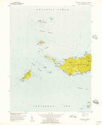 1955 Western St. Thomas1956 Print · USGSWestern St Thomas and its surrounding archipelago are caught in detail during the mid-fifties, showing the island's steep peaks and coastal roads. Trace the island's geography from the heights of Bordeaux Hill down to the unique crossing at the Mermaids Chair or the small settlement at Fortuna.5 unique versions available
 - 2013 Map of Savana Passage, 2013 Print
 2013 Savana Passage2013 Print · USGSCovers Fortuna, including United States Virgin Islands, Saint Thomas - Saint John District, and other nearby areas
 - 2024 Map of Savana Passage, 2024 Print
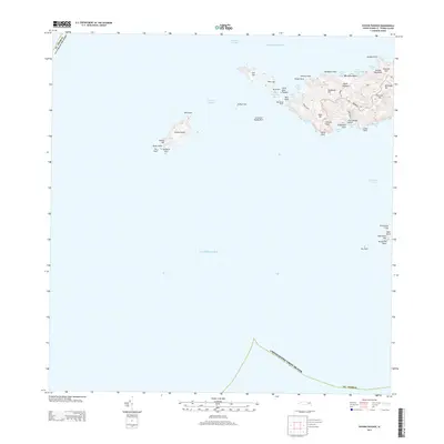
 2024 Savana Passage2024 Print · USGSThe western end of Saint Thomas and its surrounding cays are documented here in detail, showing the modern layout of the islands. Trace the roads and ridges connecting Bordeaux and Fortuna, or explore the isolated coastlines of Savana Island and Botany Bay.
End of results
Showing maps 1-3 of 3
Top cities near Fortuna
Frequently asked questions
- What are the different types of historical maps available for Fortuna?
- What is the oldest map of Fortuna?
- Where can I purchase historical maps of Fortuna for my home or office?
- Where can I download high-res historical maps of Fortuna?
- Are there historical topographic maps available for Fortuna?
- Is there historical aerial imagery available for Fortuna?
- Where are historical maps of Fortuna sourced from?