1960s Maps of Battles Wharf, Alabama
Explore 2 historic maps of Battles Wharf from the 1960s. These maps offer a rare glimpse into what life looked like during the 1960s — showing old roads, neighborhoods, homes, and landmarks that have changed or disappeared over time.
Whether you're researching your family's past, planning a metal detecting trip, or studying how Battles Wharf's landscape evolved across the 1960s, these high-resolution maps are a powerful tool for exploring the history of this region.
- Focus on a specific era: All maps on this page are from the 1960s, giving you a focused view of this time period.
- See what’s changed: Compare century-old streets, trails, and buildings to today's modern landscape using overlays and satellite layers.
- Research with precision: Use these maps for genealogy, historical research, land use analysis, or educational projects.
- View, download, or print: Maps are fully viewable online in high resolution, and can be downloaded or printed for your own records.
Start exploring Battles Wharf's history through authentic maps from the 1960s. This is your window into the past.
Battles Wharf, AL maps
(2)- 1960 Map of Pensacola
 1960 Pensacola1960 Print · USGSThe Florida Panhandle and Alabama's eastern shore are shown during a period of rapid military and coastal growth. Genealogists and historians can trace the mid-century footprints of Warrington, the Pensacola NAS (Chevalier), and the Blackwater River timber lands.
 - 1966 Map of Point Clear, 1975 Print
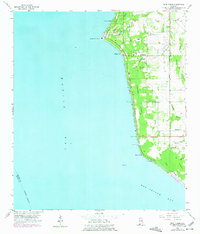 1966 Point Clear1975 Print · USGSBaldwin County's eastern shoreline is captured in the mid-1960s as coastal recreation and rural life began to coalesce. Genealogists and local historians can trace family sites at Confederate Rest Cem or locate historic water access points like Battles Wharf and Mullet Point.
End of results
Showing maps 1-2 of 2
Top cities near Battles Wharf
- Mobile historical maps
- Daphne historical maps
- Fairhope historical maps
- Foley historical maps
- Prichard historical maps
- Gulf Shores historical maps
See more
Frequently asked questions
- What are the different types of historical maps available for Battles Wharf?
- What is the oldest map of Battles Wharf?
- Where can I purchase historical maps of Battles Wharf for my home or office?
- Where can I download high-res historical maps of Battles Wharf?
- Are there historical topographic maps available for Battles Wharf?
- Is there historical aerial imagery available for Battles Wharf?
- Where are historical maps of Battles Wharf sourced from?