Old Maps of Dauphin Island, Alabama
Explore 71 old maps of Dauphin Island, spanning from 1921 to today. These high-resolution historic maps reveal how streets, neighborhoods, landmarks, and natural features evolved over time — perfect for genealogy, metal detecting, research, and local history exploration.
What you can do with these maps:
- See how Dauphin Island changed over time: Compare historical maps to modern-day views to trace roads, homesites, rail lines & more.
- View detailed metadata: Each map includes creators, publishers, year, scale, and archive source.
- Overlay maps with satellite & LiDAR: Visualize the past alongside modern tools to explore terrain & human change.
- Trusted historical sources: Maps sourced from the USGS, Library of Congress, and other archives.
- Access maps your way: View online, download high-res files, or order prints for personal or research use.
Start exploring old maps of Dauphin Island to uncover forgotten places, hidden landmarks, and the deep history beneath your feet.
Dauphin Island, AL maps
(71)- 1921 Map of Grand Bay
 1921 Grand Bay1921 Print · USGSThe Mississippi and Alabama borderlands meet at the Gulf Coast during the early twentieth century, showing a landscape of tidal marshes and emerging rail towns. Genealogists and historians can trace the early footprints of Pecan, Orange Grove, and the shoreline Oyster factory.
 - 1921 Map of Petit Bois Island
 1921 Petit Bois Island1921 Print · USGSThe barrier landscapes of the Gulf Coast appear in sharp detail during the early twentieth century. Researchers can trace the Alabama Mississippi Boundary Line across Petit Bois Island and locate the U.S. Gov't Reservation.
 - 1921 Map of Dauphin Island
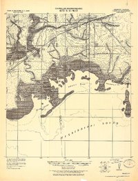
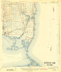
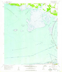
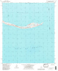
 1921 Dauphin Island1921 Print · USGSThe entrance to Mobile Bay comes alive in the early twentieth century as a landscape of coastal defense and maritime navigation. You can trace the battery positions at Fort Morgan and Fort Gaines or locate the Sand Island Light.
 - 1921 Map of Delchamps
 1921 Delchamps1921 Print · USGSCoastal Mobile County comes alive in this early twentieth-century survey of the bays and sounds before modern development. Genealogists and historians can trace family-named settlements like Delchamps and Prosser, or locate maritime landmarks such as the Oyster Factory and the Mobile & Ohio RR.
 - 1941 Map of Cedar Point
 1941 Cedar Point1941 Print · USGSCoastal Mobile County is shown here just before the mid-century, from the fishing docks of Bayou La Batre to the shores of Dauphin Island. Researchers can trace the path of the G M and O railroad or locate old landings at Mon Louis and Alabama Port.2 unique versions available
 - 1942 Map of Petit Bois Island
 1942 Petit Bois Island1942 Print · USGSCoastal barrier islands along the Alabama and Mississippi border appear in this wartime survey, showing the shifting sands before modern development. Maritime researchers can trace the navigational landscape of Petit Bois Pass and the position of the Horn Island L H.
 - 1942 Map of Fort Morgan
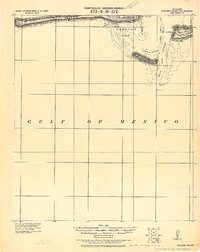
 1942 Fort Morgan1942 Print · USGSThe mouth of Mobile Bay is captured in the early 1940s, highlighting the strategic coastal defenses of the Alabama shore. Nautical researchers can trace the Main Channel past Fort Morgan and the site of Fort Gaines to the Sand Island L H.3 unique versions available
 - 1943 Map of Cedar Point
 1943 Cedar Point1943 Print · USGSThe Alabama Gulf Coast was a hub of maritime trade and seafood harvesting in the early 1940s. Trace the path of the G M and O (Abandoned) railroad near Bayou La Batre or locate coastal settlements like Alabama Port and Mon Louis.4 unique versions available
 - 1943 Map of Grand Bay
 1943 Grand Bay1943 Print · USGSCoastal Alabama and Mississippi are captured here in the early 1940s, showing the vital rail-and-water networks of the Gulf. Genealogists and researchers can trace family lands near Bayou La Batre, the Orange Lake Sch, or the maritime settlement at Coden.2 unique versions available
 - 1953 Map of Mobile, 1968 Print
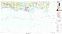
 1953 Mobile1968 Print · USGSThe Gulf Coast comes alive in this mid-century survey, from the streets of Mobile to the marshes of New Orleans. Trace family roots in coastal towns like Pass Christian and Bayou La Batre or locate military landmarks including Keesler AFB.3 unique versions available
 - 1957 Map of Mobile
 1957 Mobile1957 Print · USGSThe Gulf Coast in the mid-1950s reveals a bustling corridor of rail-and-river commerce connecting Alabama to Louisiana. Genealogists and historians can trace old settlements and military hubs from Keesler Afb to the coastal reaches of Ship Island and Bogalusa.3 unique versions available
 - 1958 Map of Little Dauphin Island
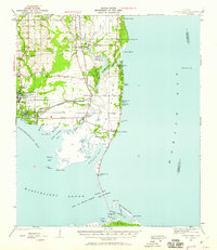
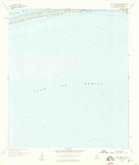
 1958 Little Dauphin Island1958 Print · USGSMobile Bay and the Alabama coastline are captured here in the late fifties, showing the vital maritime corridors of the Gulf. Researchers can trace the early road network on Dauphin Island and locate heritage sites like Indian Mound Park or Alabama Port.3 unique versions available
 - 1958 Map of Fort Morgan, 1959 Print
 1958 Fort Morgan1959 Print · USGSThe entrance to Mobile Bay in the late fifties was defined by its coastal defenses and shifting maritime channels. History buffs can trace the layouts of Fort Morgan and Fort Gaines or locate landmarks like the Sand Island Lighthouse and Bienville Beach.4 unique versions available
 - 1958 Map of Heron Bay, 1959 Print
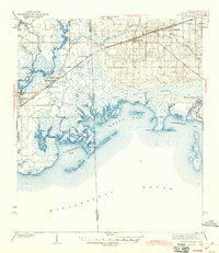
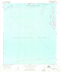
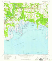
 1958 Heron Bay1959 Print · USGSCoastal Alabama at the end of the fifties reveals a complex network of bayous and sounds before extensive modern development. Trace the early shoreline of Dauphin Island and find historic water crossings at Grants Pass and Cedar Point.3 unique versions available
 - 1958 Map of Fort Morgan NW, 1959 Print
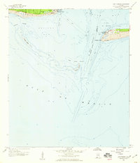
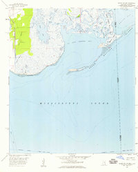
 1958 Fort Morgan NW1959 Print · USGSDauphin Island during the late fifties reveals an emerging coastal settlement and its primary thoroughfare, Bienville Blvd. Researchers can trace early residential expansion and compare historical shorelines along the Mississippi Sound.2 unique versions available
 - 1958 Map of Isle Aux Herbes, 1959 Print
 1958 Isle Aux Herbes1959 Print · USGSCoastal Mobile County is captured in the late fifties as a landscape of shifting barrier islands and essential maritime routes. Genealogists and historians can trace the old shorelines of Isle Aux Herbes and the strategic Intracoastal Waterway.2 unique versions available
 - 1958 Map of Grand Bay SW, 1959 Print
 1958 Grand Bay SW1959 Print · USGSThe Mississippi and Alabama shoreline comes alive in this mid-century survey of the coastal marshes and tidal bayous. Trace the historic route of the Louisville and Nashville railroad or explore the shifting sands of the Grand Batture Islands and Bangs Lake.3 unique versions available
 - 1958 Map of Petit Bois Island, 1959 Print
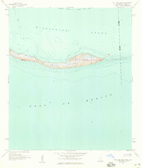 1958 Petit Bois Island1959 Print · USGSPetit Bois Island straddles the Alabama and Mississippi state line in the late fifties, serving as a vital barrier for the sound. Maritime researchers can trace the Intracoastal Waterway and locate the historic Light and Piles along the coast.2 unique versions available
 - 1958 Map of Petit Bois Pass, 1959 Print
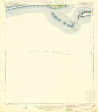
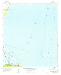
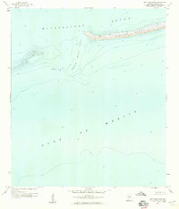 1958 Petit Bois Pass1959 Print · USGSThe Alabama coastline and the tip of Dauphin Island are captured in the late fifties, showing the shifting shoals of the Mississippi Sound. Maritime researchers can locate specific Wreckage and trace the depths of Petit Bois Pass.2 unique versions available
 - 1958 Map of Grand Bay, 1959 Print
 1958 Grand Bay1959 Print · USGSThe coastal borderlands of Alabama and Mississippi come alive in the late fifties, where rail and river networks meet the Gulf. Genealogists and local historians can trace family-named sites like Dees Cem and Kivisto Cem or explore the working waterfronts of Bayou La Batre and Moss Point.2 unique versions available
 - 1960 Map of Mobile
 1960 Mobile1960 Print · USGSThe Gulf Coast at the dawn of the sixties shows a landscape of busy ports, military airbases, and barrier islands. Trace the rail lines of the Louisville & Nashville through BILOXI and Pascagoula or find family history in towns like Bayou La Batre and Poplarville.
 - 1963 Map of Mobile
 1963 Mobile1963 Print · USGSThe Gulf Coast at the dawn of the sixties shows a thriving maritime and military corridor from Louisiana to Alabama. Genealogists and historians can trace rail lines like the Louisville & Nashville RR and find landmarks from Brookley AFB to Fort Morgan.
 - 1965 Map of Mobile
 1965 Mobile1965 Print · USGSThe Gulf Coast at mid-century reveals a landscape of expanding ports and vital military installations from Louisiana to Alabama. Genealogists and historians can trace the growth of Biloxi, Pascagoula, and Mobile, alongside the sprawling De Soto National Forest.
 - 1982 Map of Biloxi
 1982 Biloxi1982 Print · USGSThe Mississippi and Alabama coastlines are captured in the early eighties as industrial hubs and wildlife refuges shaped the shoreline. Trace maritime and military history through Fort Morgan, Keesler Air Force Base, and the barrier islands of Gulf Islands National Seashore.2 unique versions available
 - 1982 Map of Petit Bois Island, 1983 Print
 1982 Petit Bois Island1983 Print · USGSThe barrier island landscape of the Mississippi coast is captured here in the early eighties, showing the narrow stretch of Petit Bois Island. Maritime historians can trace the Horn Island Lighthouse and the state boundary line between Alabama and Mississippi.2 unique versions available
Showing maps 1-25 of 71
Top cities near Dauphin Island
Frequently asked questions
- What are the different types of historical maps available for Dauphin Island?
- What is the oldest map of Dauphin Island?
- Where can I purchase historical maps of Dauphin Island for my home or office?
- Where can I download high-res historical maps of Dauphin Island?
- Are there historical topographic maps available for Dauphin Island?
- Is there historical aerial imagery available for Dauphin Island?
- Where are historical maps of Dauphin Island sourced from?