1940s Maps of Dauphin Island, Alabama
Explore 5 historic maps of Dauphin Island from the 1940s. These maps offer a rare glimpse into what life looked like during the 1940s — showing old roads, neighborhoods, homes, and landmarks that have changed or disappeared over time.
Whether you're researching your family's past, planning a metal detecting trip, or studying how Dauphin Island's landscape evolved across the 1940s, these high-resolution maps are a powerful tool for exploring the history of this region.
- Focus on a specific era: All maps on this page are from the 1940s, giving you a focused view of this time period.
- See what’s changed: Compare century-old streets, trails, and buildings to today's modern landscape using overlays and satellite layers.
- Research with precision: Use these maps for genealogy, historical research, land use analysis, or educational projects.
- View, download, or print: Maps are fully viewable online in high resolution, and can be downloaded or printed for your own records.
Start exploring Dauphin Island's history through authentic maps from the 1940s. This is your window into the past.
Dauphin Island, AL maps
(5)- 1941 Map of Cedar Point
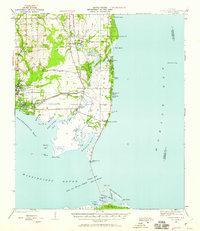 1941 Cedar Point1941 Print · USGSCoastal Mobile County is shown here just before the mid-century, from the fishing docks of Bayou La Batre to the shores of Dauphin Island. Researchers can trace the path of the G M and O railroad or locate old landings at Mon Louis and Alabama Port.2 unique versions available
 - 1942 Map of Petit Bois Island
 1942 Petit Bois Island1942 Print · USGSCoastal barrier islands along the Alabama and Mississippi border appear in this wartime survey, showing the shifting sands before modern development. Maritime researchers can trace the navigational landscape of Petit Bois Pass and the position of the Horn Island L H.
 - 1942 Map of Fort Morgan
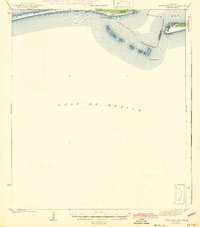 1942 Fort Morgan1942 Print · USGSThe mouth of Mobile Bay is captured in the early 1940s, highlighting the strategic coastal defenses of the Alabama shore. Nautical researchers can trace the Main Channel past Fort Morgan and the site of Fort Gaines to the Sand Island L H.3 unique versions available
 - 1943 Map of Cedar Point
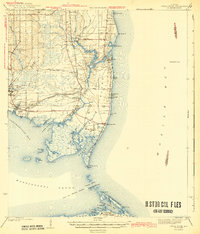 1943 Cedar Point1943 Print · USGSThe Alabama Gulf Coast was a hub of maritime trade and seafood harvesting in the early 1940s. Trace the path of the G M and O (Abandoned) railroad near Bayou La Batre or locate coastal settlements like Alabama Port and Mon Louis.4 unique versions available
 - 1943 Map of Grand Bay
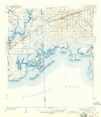 1943 Grand Bay1943 Print · USGSCoastal Alabama and Mississippi are captured here in the early 1940s, showing the vital rail-and-water networks of the Gulf. Genealogists and researchers can trace family lands near Bayou La Batre, the Orange Lake Sch, or the maritime settlement at Coden.2 unique versions available
End of results
Showing maps 1-5 of 5
Top cities near Dauphin Island
Frequently asked questions
- What are the different types of historical maps available for Dauphin Island?
- What is the oldest map of Dauphin Island?
- Where can I purchase historical maps of Dauphin Island for my home or office?
- Where can I download high-res historical maps of Dauphin Island?
- Are there historical topographic maps available for Dauphin Island?
- Is there historical aerial imagery available for Dauphin Island?
- Where are historical maps of Dauphin Island sourced from?