1960s Maps of Bakerhill, Alabama
Explore 2 historic maps of Bakerhill from the 1960s. These maps offer a rare glimpse into what life looked like during the 1960s — showing old roads, neighborhoods, homes, and landmarks that have changed or disappeared over time.
Whether you're researching your family's past, planning a metal detecting trip, or studying how Bakerhill's landscape evolved across the 1960s, these high-resolution maps are a powerful tool for exploring the history of this region.
- Focus on a specific era: All maps on this page are from the 1960s, giving you a focused view of this time period.
- See what’s changed: Compare century-old streets, trails, and buildings to today's modern landscape using overlays and satellite layers.
- Research with precision: Use these maps for genealogy, historical research, land use analysis, or educational projects.
- View, download, or print: Maps are fully viewable online in high resolution, and can be downloaded or printed for your own records.
Start exploring Bakerhill's history through authentic maps from the 1960s. This is your window into the past.
Bakerhill, AL maps
(2)- 1968 Map of Baker Hill, 1970 Print
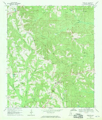 1968 Baker Hill1970 Print · USGSSoutheast Alabama in the late sixties reveals a landscape shaped by historical lines and rural tradition. Genealogists and historians can trace the Old Indian Treaty Boundary while locating community landmarks like Rocky Mount Ch, Peggy Bottom, and St Pauls Ch.
 - 1969 Map of Lawrenceville, 1971 Print
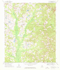 1969 Lawrenceville1971 Print · USGSHenry County rural life and the headwaters of the Choctawhatchee River are documented here in the late sixties. Researchers can trace family sites near Lawrenceville, Richards Crossroads, and numerous country steeples like Union Grove Ch.
End of results
Showing maps 1-2 of 2
Top cities near Bakerhill
- Eufaula historical maps
- Abbeville historical maps
- Clayton historical maps
- Fort Gaines historical maps
- Georgetown historical maps
- Blue Springs historical maps
Top neighborhoods of Bakerhill
Frequently asked questions
- What are the different types of historical maps available for Bakerhill?
- What is the oldest map of Bakerhill?
- Where can I purchase historical maps of Bakerhill for my home or office?
- Where can I download high-res historical maps of Bakerhill?
- Are there historical topographic maps available for Bakerhill?
- Is there historical aerial imagery available for Bakerhill?
- Where are historical maps of Bakerhill sourced from?