1960s Maps of Eufaula, Alabama
Explore 5 historic maps of Eufaula from the 1960s. These maps offer a rare glimpse into what life looked like during the 1960s — showing old roads, neighborhoods, homes, and landmarks that have changed or disappeared over time.
Whether you're researching your family's past, planning a metal detecting trip, or studying how Eufaula's landscape evolved across the 1960s, these high-resolution maps are a powerful tool for exploring the history of this region.
- Focus on a specific era: All maps on this page are from the 1960s, giving you a focused view of this time period.
- See what’s changed: Compare century-old streets, trails, and buildings to today's modern landscape using overlays and satellite layers.
- Research with precision: Use these maps for genealogy, historical research, land use analysis, or educational projects.
- View, download, or print: Maps are fully viewable online in high resolution, and can be downloaded or printed for your own records.
Start exploring Eufaula's history through authentic maps from the 1960s. This is your window into the past.
Eufaula, AL maps
(5)- 1967 Map of Georgetown, 1970 Print
 1967 Georgetown1970 Print · USGSThe Quitman County shoreline underwent a dramatic shift in the late sixties as the Chattahoochee River valley was reshaped by new reservoirs. Researchers can trace the submerged geography near Georgetown and locate rural landmarks like Keglar Sch or Bumbleton Courthouse Cem.2 unique versions available
 - 1968 Map of Eufaula North, 1970 Print
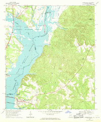
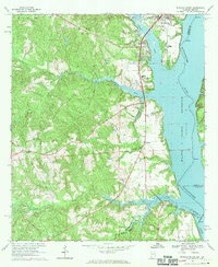
 1968 Eufaula North1970 Print · USGSThe Alabama-Georgia borderlands near Eufaula are captured here in the late sixties, just as the reservoir reshaped the riverfront. Researchers can trace family roots at St James Ch, Shorter Cem, and the historic rail corridor of the Central of Georgia.2 unique versions available
 - 1968 Map of Baker Hill, 1970 Print
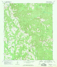 1968 Baker Hill1970 Print · USGSSoutheast Alabama in the late sixties reveals a landscape shaped by historical lines and rural tradition. Genealogists and historians can trace the Old Indian Treaty Boundary while locating community landmarks like Rocky Mount Ch, Peggy Bottom, and St Pauls Ch.
 - 1968 Map of White Oak, 1970 Print
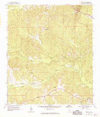 1968 White Oak1970 Print · USGSBarbour County's rural heartland is captured here in the late 1960s. Genealogists can trace family roots through sites like the Perkins-Evans Cem, Wyecott Plantation, and Palmyra Ch along the Central of Georgia rail line.
 - 1968 Map of Eufaula South, 1970 Print
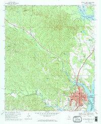
 1968 Eufaula South1970 Print · USGSNear the Alabama-Georgia border in the late sixties, the landscape around the reservoir reveals a mix of river industry and deep-rooted rural life. Genealogists and local historians can trace the Old Indian Treaty Bdy and locate landmarks like Bluff City Sch and Epworth Ch.2 unique versions available
End of results
Showing maps 1-5 of 5
Top cities near Eufaula
Top neighborhoods of Eufaula
- Hoboken historical maps
- Terese historical maps
- Osco historical maps
- Wylaunee historical maps
- Tullis historical maps
Frequently asked questions
- What are the different types of historical maps available for Eufaula?
- What is the oldest map of Eufaula?
- Where can I purchase historical maps of Eufaula for my home or office?
- Where can I download high-res historical maps of Eufaula?
- Are there historical topographic maps available for Eufaula?
- Is there historical aerial imagery available for Eufaula?
- Where are historical maps of Eufaula sourced from?