1900s (20th Century) Maps of Bibb County, Alabama
Explore 39 historic maps of Bibb County from the 1900s (20th Century). These maps offer a rare glimpse into what life looked like during the 1900s — showing old roads, neighborhoods, homes, and landmarks that have changed or disappeared over time.
Whether you're researching your family's past, planning a metal detecting trip, or studying how Bibb County's landscape evolved across the 1900s, these high-resolution maps are a powerful tool for exploring the history of this region.
- Focus on a specific era: All maps on this page are from the 1900s, giving you a focused view of this time period.
- See what’s changed: Compare century-old streets, trails, and buildings to today's modern landscape using overlays and satellite layers.
- Research with precision: Use these maps for genealogy, historical research, land use analysis, or educational projects.
- View, download, or print: Maps are fully viewable online in high resolution, and can be downloaded or printed for your own records.
Start exploring Bibb County's history through authentic maps from the 1900s. This is your window into the past.
Bibb County, AL maps
(39)- 1910 Map of Montevallo
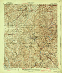
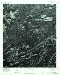
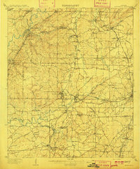 1910 Montevallo1910 Print · USGSCentral Alabama’s coal and iron corridor is captured here at a peak of industrial expansion. Researchers can trace the heritage of vanished mining camps and family landmarks from Boothon to the Bibb Furnace (RUINS) and Sessions Chapel.4 unique versions available
 - 1931 Map of Cottondale
 1931 Cottondale1931 Print · USGSTuscaloosa County at the start of the 1930s shows a landscape of timber rails and rural churches. Genealogists and historians can trace the Kaul Lumber Co (Abandoned) line or locate old community centers like Andrews Chapel and Duncanville.
 - 1934 Map of Cottondale
 1934 Cottondale1934 Print · USGSDuring the mid-1930s, the rail corridors of the Southern Railway and Mobile and Ohio Railroad shaped the growth of eastern Tuscaloosa County. Genealogists can trace family footprints near Cottondale and Duncanville or locate long-standing landmarks like Emerson Chapel and Howell Sch.3 unique versions available
 - 1934 Map of Blocton
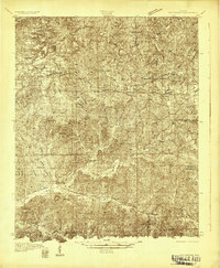
 1934 Blocton1934 Print · USGSCentral Alabama's coal and rail corridor comes to life in the 1930s, showing the intersection of the Cahaba River and intensive industrial development. Researchers can locate old mining sites like Hill Creek Mine and numerous rural landmarks including Rock Institute Sch and Ada Chapel.3 unique versions available
 - 1940 Map of Blocton
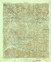
 1940 Blocton1940 Print · USGSCentral Alabama's mining and river country is captured here just before the Second World War, centered on the coal hubs of Bibb County. Researchers can trace family roots through numerous rural landmarks like Mt Olivet Ch, Gray Hill Sch, and the rail junction at Blocton Junc.2 unique versions available
 - 1953 Map of Montgomery, 1964 Print
 1953 Montgomery1964 Print · USGSCentral Alabama's river-and-rail corridor is mapped here in the mid-fifties, showing the vital connections between the capital and the Black Belt. Genealogists and historians can trace rail depots and crossroads from Marion Junction to Wetumpka, alongside landmarks like Craig AFB.4 unique versions available
 - 1953 Map of Birmingham, 1964 Print
 1953 Birmingham1964 Print · USGSCentral Alabama at mid-century shows a landscape defined by industrial expansion and the iron-rich ridges surrounding Birmingham. Researchers can trace the extensive rail networks of the L & N RR or locate historic federal sites like the Anniston Ordnance Depot.4 unique versions available
 - 1956 Map of Birmingham
 1956 Birmingham1956 Print · USGSCentral Alabama in the mid-fifties exhibits a landscape of growing cities and deep-rooted industrial corridors. Genealogists and historians can trace the development of suburban Mountain Brook or locate regional hubs like Sylacauga and Jasper.
 - 1956 Map of Montgomery
 1956 Montgomery1956 Print · USGSCentral Alabama in the mid-1950s shows a landscape defined by its great river systems and a booming military aviation presence. Genealogists and historians can trace the rail corridors of the Southern Railway and locate tactical bases like Maxwell AFB and Craig AFB.
 - 1957 Map of Birmingham
 1957 Birmingham1957 Print · USGSNorth-Central Alabama in the mid-fifties is an industrial powerhouse centered on the steel valleys and sprawling iron ridges. Genealogists and historians can trace the rail-linked growth of Birmingham and Tuscaloosa, or locate rural landmarks like Talladega College and the Anniston Ordnance Depot.
 - 1957 Map of Montgomery
 1957 Montgomery1957 Print · USGSCentral Alabama in the mid-fifties is defined by the winding Alabama River and a strategic network of military bases and rail lines. Trace family roots in Montgomery and Selma, or locate landmarks like Craig AFB and the State Capitol before the interstate era.
 - 1969 Map of Duncanville, 1972 Print
 1969 Duncanville1972 Print · USGSDuncanville and the surrounding Tuscaloosa County hinterlands are shown here in the late sixties as the timber and rail industries shaped the local landscape. Genealogists can locate family landmarks like Mt Sinai Ch Cem, South Sandy Cem, and the Shiloh Lookout Tower.3 unique versions available
 - 1969 Map of Pearson, 1972 Print
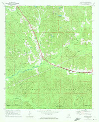
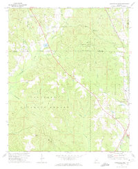
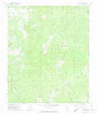
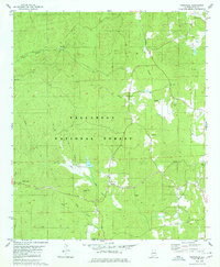
 1969 Pearson1972 Print · USGSBibb and Tuscaloosa Counties in the late sixties were defined by the heavy rail traffic of the Gulf Mobile and Ohio and the deep woods of the Talladega National Forest. Genealogists and local historians can trace the rural communities around Hagler, Pearson, and landmarks like Hubbard Springs Ch.3 unique versions available
 - 1969 Map of Coaling, 1972 Print
 1969 Coaling1972 Print · USGSThe hills of Tuscaloosa County are shown during the late sixties, a landscape where the Southern railroad line connects rural coal-mining centers. Genealogists can trace family names at Thomas Chapel (Cem), Pineview Sch, and the community of Coaling.3 unique versions available
 - 1971 Map of Maplesville West, 1974 Print
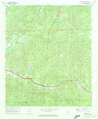
 1971 Maplesville West1974 Print · USGSChilton and Bibb Counties appear here in the early 1970s, showing a landscape defined by the expansive Talladega National Forest. Researchers can trace the Southern railroad line through Maplesville and locate rural landmarks like Rehobeth Ch and Nix Lake.2 unique versions available
 - 1971 Map of Randolph, 1974 Print
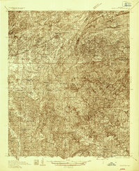
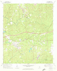
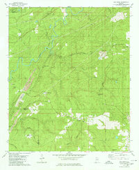
 1971 Randolph1974 Print · USGSBibb County in the early 1970s reveals a landscape of dispersed settlements and timberland connected by the Southern and Illinois Central Gulf railroads. Genealogists and historians can trace local landmarks like Howison Sch, Bibb Mill, and Oakley.2 unique versions available
 - 1975 Map of Montevallo SW, 1977 Print
 1975 Montevallo SW1977 Print · USGSBibb County timberlands and small settlements are captured in high detail in the mid-seventies just as modern land-use patterns emerged. Genealogists and local historians can trace the clearings and crossroads around Aldrich and the historic area of Brierfield.
 - 1975 Map of Montevallo NW, 1977 Print
 1975 Montevallo NW1977 Print · USGSShelby County emerges in clear aerial detail during the mid-seventies, showing the intersection of heavy industry and the winding Cahaba River. Genealogists and historians can trace old road alignments and early surface mining footprints near the river's edge.
 - 1975 Map of Blocton NE, 1977 Print
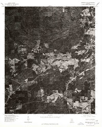
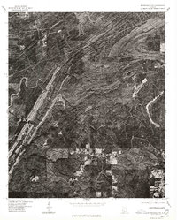
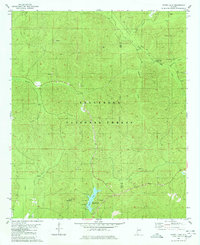
 1975 Blocton NE1977 Print · USGSIn the mid-1970s, the terrain of Bibb County was captured in striking detail via this aerial orthophotoquad. You can examine the settlement patterns around Green Pond and trace the timber tracks and ridgelines that define this rural landscape.
 - 1979 Map of West Blocton West, 1980 Print
 1979 West Blocton West1980 Print · USGSBibb County communities and coal works are documented in the late seventies as the industrial landscape shifted. Researchers can trace family sites like Johnstown Cem, locate old crossings at Smiths Ford, and follow the Old Railroad Grade.
 - 1979 Map of Aldrich, 1980 Print
 1979 Aldrich1980 Print · USGSBibb County in the late seventies reveals a landscape shaped by the iron industry and the Southern railway. Researchers can locate family landmarks like Carlton Hill Ch, Moore Cem, and the historic Bibb Furnace Ruins.2 unique versions available
 - 1979 Map of Pea Ridge, 1980 Print
 1979 Pea Ridge1980 Print · USGSThe Cahaba River valley in the late seventies is captured here at a peak of industrial activity. Genealogists can trace family footprints through settlements like Sawmill Town and Boothton, or locate rural landmarks such as Antioch Ch and the Boothton Cem.2 unique versions available
 - 1979 Map of Harrisburg, 1980 Print
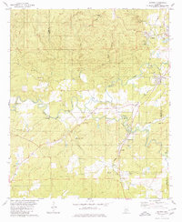
 1979 Harrisburg1980 Print · USGSThe rural landscapes of Perry and Bibb Counties come into focus during the late 1970s, dominated by the timberlands of the national forest and the winding river. Genealogists can trace family roots through several local landmarks like Antioch Ch, Perkins Cem, and Paynes Chapel.2 unique versions available
 - 1979 Map of Pondville, 1980 Print
 1979 Pondville1980 Print · USGSWestern Alabama’s timberlands and rural communities are captured here in the late seventies. Genealogists can locate several family-named landmarks and old country burial grounds like Avery Cem, Elam Cem, and the cluster at Mulberry Cems.2 unique versions available
 - 1980 Map of Payne Lake
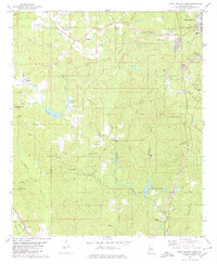
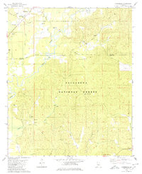
 1980 Payne Lake1980 Print · USGSDeep in the Alabama woodlands during the 1980s, this area showcases the intersection of forest management and public recreation. Trace local history at Pine Flat Ch, the Old Railroad Grade, and the shores of Payne Lake.2 unique versions available
Showing maps 1-25 of 39
Top cities of Bibb County
Frequently asked questions
- What are the different types of historical maps available for Bibb County?
- What is the oldest map of Bibb County?
- Where can I purchase historical maps of Bibb County for my home or office?
- Where can I download high-res historical maps of Bibb County?
- Are there historical topographic maps available for Bibb County?
- Is there historical aerial imagery available for Bibb County?
- Where are historical maps of Bibb County sourced from?