1970s Maps of Bibb County, Alabama
Explore 10 historic maps of Bibb County from the 1970s. These maps offer a rare glimpse into what life looked like during the 1970s — showing old roads, neighborhoods, homes, and landmarks that have changed or disappeared over time.
Whether you're researching your family's past, planning a metal detecting trip, or studying how Bibb County's landscape evolved across the 1970s, these high-resolution maps are a powerful tool for exploring the history of this region.
- Focus on a specific era: All maps on this page are from the 1970s, giving you a focused view of this time period.
- See what’s changed: Compare century-old streets, trails, and buildings to today's modern landscape using overlays and satellite layers.
- Research with precision: Use these maps for genealogy, historical research, land use analysis, or educational projects.
- View, download, or print: Maps are fully viewable online in high resolution, and can be downloaded or printed for your own records.
Start exploring Bibb County's history through authentic maps from the 1970s. This is your window into the past.
Bibb County, AL maps
(10)- 1971 Map of Maplesville West, 1974 Print
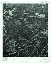
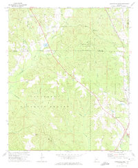 1971 Maplesville West1974 Print · USGSChilton and Bibb Counties appear here in the early 1970s, showing a landscape defined by the expansive Talladega National Forest. Researchers can trace the Southern railroad line through Maplesville and locate rural landmarks like Rehobeth Ch and Nix Lake.2 unique versions available
 - 1971 Map of Randolph, 1974 Print
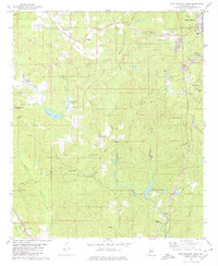
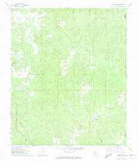 1971 Randolph1974 Print · USGSBibb County in the early 1970s reveals a landscape of dispersed settlements and timberland connected by the Southern and Illinois Central Gulf railroads. Genealogists and historians can trace local landmarks like Howison Sch, Bibb Mill, and Oakley.2 unique versions available
 - 1975 Map of Montevallo SW, 1977 Print
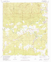
 1975 Montevallo SW1977 Print · USGSBibb County timberlands and small settlements are captured in high detail in the mid-seventies just as modern land-use patterns emerged. Genealogists and local historians can trace the clearings and crossroads around Aldrich and the historic area of Brierfield.
 - 1975 Map of Montevallo NW, 1977 Print
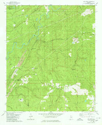
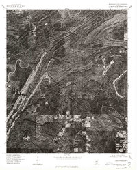 1975 Montevallo NW1977 Print · USGSShelby County emerges in clear aerial detail during the mid-seventies, showing the intersection of heavy industry and the winding Cahaba River. Genealogists and historians can trace old road alignments and early surface mining footprints near the river's edge.
 - 1975 Map of Blocton NE, 1977 Print
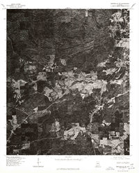
 1975 Blocton NE1977 Print · USGSIn the mid-1970s, the terrain of Bibb County was captured in striking detail via this aerial orthophotoquad. You can examine the settlement patterns around Green Pond and trace the timber tracks and ridgelines that define this rural landscape.
 - 1979 Map of West Blocton West, 1980 Print
 1979 West Blocton West1980 Print · USGSBibb County communities and coal works are documented in the late seventies as the industrial landscape shifted. Researchers can trace family sites like Johnstown Cem, locate old crossings at Smiths Ford, and follow the Old Railroad Grade.
 - 1979 Map of Aldrich, 1980 Print
 1979 Aldrich1980 Print · USGSBibb County in the late seventies reveals a landscape shaped by the iron industry and the Southern railway. Researchers can locate family landmarks like Carlton Hill Ch, Moore Cem, and the historic Bibb Furnace Ruins.2 unique versions available
 - 1979 Map of Pea Ridge, 1980 Print
 1979 Pea Ridge1980 Print · USGSThe Cahaba River valley in the late seventies is captured here at a peak of industrial activity. Genealogists can trace family footprints through settlements like Sawmill Town and Boothton, or locate rural landmarks such as Antioch Ch and the Boothton Cem.2 unique versions available
 - 1979 Map of Harrisburg, 1980 Print
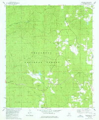
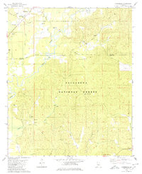 1979 Harrisburg1980 Print · USGSThe rural landscapes of Perry and Bibb Counties come into focus during the late 1970s, dominated by the timberlands of the national forest and the winding river. Genealogists can trace family roots through several local landmarks like Antioch Ch, Perkins Cem, and Paynes Chapel.2 unique versions available
 - 1979 Map of Pondville, 1980 Print
 1979 Pondville1980 Print · USGSWestern Alabama’s timberlands and rural communities are captured here in the late seventies. Genealogists can locate several family-named landmarks and old country burial grounds like Avery Cem, Elam Cem, and the cluster at Mulberry Cems.2 unique versions available
End of results
Showing maps 1-10 of 10
Top cities of Bibb County
Frequently asked questions
- What are the different types of historical maps available for Bibb County?
- What is the oldest map of Bibb County?
- Where can I purchase historical maps of Bibb County for my home or office?
- Where can I download high-res historical maps of Bibb County?
- Are there historical topographic maps available for Bibb County?
- Is there historical aerial imagery available for Bibb County?
- Where are historical maps of Bibb County sourced from?