1960s Maps of Calhoun County, Alabama
Explore 5 historic maps of Calhoun County from the 1960s. These maps offer a rare glimpse into what life looked like during the 1960s — showing old roads, neighborhoods, homes, and landmarks that have changed or disappeared over time.
Whether you're researching your family's past, planning a metal detecting trip, or studying how Calhoun County's landscape evolved across the 1960s, these high-resolution maps are a powerful tool for exploring the history of this region.
- Focus on a specific era: All maps on this page are from the 1960s, giving you a focused view of this time period.
- See what’s changed: Compare century-old streets, trails, and buildings to today's modern landscape using overlays and satellite layers.
- Research with precision: Use these maps for genealogy, historical research, land use analysis, or educational projects.
- View, download, or print: Maps are fully viewable online in high resolution, and can be downloaded or printed for your own records.
Start exploring Calhoun County's history through authentic maps from the 1960s. This is your window into the past.
Calhoun County, AL maps
(5)- 1967 Map of Piedmont NW, 1969 Print
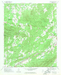 1967 Piedmont NW1969 Print · USGSNortheast Alabama in the late sixties reveals a landscape of mountain ridges and rail-side settlements. Genealogists can trace family landmarks and rural life through Knightens Crossroads, Webb Sch, and the historic tracks of the Southern Railway.3 unique versions available
 - 1967 Map of Piedmont, 1969 Print
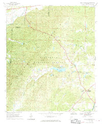
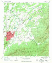 1967 Piedmont1969 Print · USGSPiedmont and the surrounding valleys of the Alabama Piedmont are captured in the late sixties as the region's rail networks and mountain industry thrived. Researchers can trace family sites from McFrey Crossroads to Vigo, or locate old landmarks like Bethune Ch and Goshen Cem.3 unique versions available
 - 1967 Map of Jacksonville East, 1970 Print
 1967 Jacksonville East1970 Print · USGSNortheast Calhoun County's ridges and rail junctions are documented here during the late sixties. Trace family history through Salem Ch and McCain Cem, or follow the industrial legacy of the Southern Railway through Merrelton.4 unique versions available
 - 1967 Map of Piedmont SE, 1970 Print
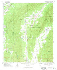
 1967 Piedmont SE1970 Print · USGSThe northern reaches of the Talladega National Forest appear here in the late sixties, showing a landscape of ridges and forest management. Researchers can trace local heritage at Grantley Ch, the Dunn Cem, and the old settlement of Liberty Hill.2 unique versions available
 - 1967 Map of Hollis Crossroads, 1970 Print
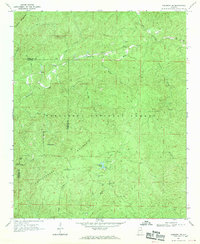
 1967 Hollis Crossroads1970 Print · USGSIn the mid-1960s, these Cleburne County highlands remained a landscape of forest and small mountain communities. Genealogists can trace family footprints near Hollis Crossroads, Pleasant Grove Jr High Sch, and rural landmarks like Bethlehem Ch.3 unique versions available
End of results
Showing maps 1-5 of 5
Top cities of Calhoun County
- Anniston historical maps
- Jacksonville historical maps
- Saks historical maps
- Piedmont historical maps
- Weaver historical maps
- Choccolocco historical maps
See more
Frequently asked questions
- What are the different types of historical maps available for Calhoun County?
- What is the oldest map of Calhoun County?
- Where can I purchase historical maps of Calhoun County for my home or office?
- Where can I download high-res historical maps of Calhoun County?
- Are there historical topographic maps available for Calhoun County?
- Is there historical aerial imagery available for Calhoun County?
- Where are historical maps of Calhoun County sourced from?