1970s Maps of Clanton, Alabama
Explore 4 historic maps of Clanton from the 1970s. These maps offer a rare glimpse into what life looked like during the 1970s — showing old roads, neighborhoods, homes, and landmarks that have changed or disappeared over time.
Whether you're researching your family's past, planning a metal detecting trip, or studying how Clanton's landscape evolved across the 1970s, these high-resolution maps are a powerful tool for exploring the history of this region.
- Focus on a specific era: All maps on this page are from the 1970s, giving you a focused view of this time period.
- See what’s changed: Compare century-old streets, trails, and buildings to today's modern landscape using overlays and satellite layers.
- Research with precision: Use these maps for genealogy, historical research, land use analysis, or educational projects.
- View, download, or print: Maps are fully viewable online in high resolution, and can be downloaded or printed for your own records.
Start exploring Clanton's history through authentic maps from the 1970s. This is your window into the past.
Clanton, AL maps
(4)- 1971 Map of Lay Dam, 1974 Print
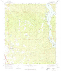 1971 Lay Dam1974 Print · USGSThe river-driven landscape of the Coosa River is captured in the early seventies, marking the industrial importance of Lay Dam. Genealogists and historians can trace local landmarks like Jumbo, Mims Ferry, and numerous rural churches including Cane Creek Ch.2 unique versions available
 - 1971 Map of Jemison East, 1974 Print
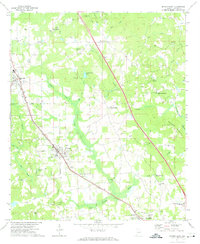 1971 Jemison East1974 Print · USGSChilton County in the early seventies is defined by the busy Louisville and Nashville rail corridor and rural crossroads. Local historians can trace family locations through numerous landmarks like Collins Chapel, Thorsby, and the Cedar Grove Ch Cem.2 unique versions available
 - 1972 Map of Clanton West, 1974 Print
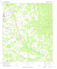
 1972 Clanton West1974 Print · USGSChilton County centers on the growth of Clanton in the early seventies as the rail lines and local creeks shaped its development. Genealogists can trace family names at Old Mt Nebo Cem and Friendship Cem or locate community hubs like New Bethel Ch.
 - 1972 Map of Clanton East, 1974 Print
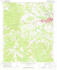
 1972 Clanton East1974 Print · USGSChilton County's landscape in the early seventies centers on the rail-driven growth around the county seat and its outlying communities. Genealogists and researchers can trace local families through many country churches and burial sites like Old Bethel Cem, Poplar Springs Ch, and Bethel Ch.2 unique versions available
End of results
Showing maps 1-4 of 4
Top cities near Clanton
- Calera historical maps
- Jemison historical maps
- Thorsby historical maps
- Marbury historical maps
- Billingsley historical maps
Top neighborhoods of Clanton
Frequently asked questions
- What are the different types of historical maps available for Clanton?
- What is the oldest map of Clanton?
- Where can I purchase historical maps of Clanton for my home or office?
- Where can I download high-res historical maps of Clanton?
- Are there historical topographic maps available for Clanton?
- Is there historical aerial imagery available for Clanton?
- Where are historical maps of Clanton sourced from?