1970s Maps of Butler, Alabama
Explore 3 historic maps of Butler from the 1970s. These maps offer a rare glimpse into what life looked like during the 1970s — showing old roads, neighborhoods, homes, and landmarks that have changed or disappeared over time.
Whether you're researching your family's past, planning a metal detecting trip, or studying how Butler's landscape evolved across the 1970s, these high-resolution maps are a powerful tool for exploring the history of this region.
- Focus on a specific era: All maps on this page are from the 1970s, giving you a focused view of this time period.
- See what’s changed: Compare century-old streets, trails, and buildings to today's modern landscape using overlays and satellite layers.
- Research with precision: Use these maps for genealogy, historical research, land use analysis, or educational projects.
- View, download, or print: Maps are fully viewable online in high resolution, and can be downloaded or printed for your own records.
Start exploring Butler's history through authentic maps from the 1970s. This is your window into the past.
Butler, AL maps
(3)- 1974 Map of Land, 1978 Print
 1974 Land1978 Print · USGSChoctaw County is captured here in the mid-seventies, showing the intersection of rural life and the St Louis - San Francisco railroad. Genealogists can trace family landmarks like Rock Springs Ch, Red Springs, and the Providence Cem among the creek-cut hills.
 - 1978 Map of Butler, 1979 Print
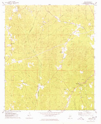
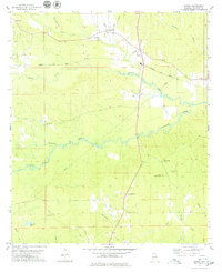
 1978 Butler1979 Print · USGSButler and Mount Sterling are shown in detail during the late 1970s as the regional landscape was shaped by aviation and local industry. Researchers can trace rural lineages through sites like Morgan Chapel, Patrician Academy, and the Butler-Choctaw Co Airport.2 unique versions available
 - 1978 Map of Jachin, 1979 Print
 1978 Jachin1979 Print · USGSChoctaw County, Alabama, is documented here in the late seventies, showing a landscape defined by timberlands and small rural communities. Genealogists can trace family landmarks at Morning Star Ch and Chapel Hill, or locate homesites near Jachin and Robjohn.2 unique versions available
End of results
Showing maps 1-3 of 3
Top cities near Butler
- Gilbertown historical maps
- Lisman historical maps
- Pennington historical maps
- Toxey historical maps
- Needham historical maps
Top neighborhoods of Butler
Frequently asked questions
- What are the different types of historical maps available for Butler?
- What is the oldest map of Butler?
- Where can I purchase historical maps of Butler for my home or office?
- Where can I download high-res historical maps of Butler?
- Are there historical topographic maps available for Butler?
- Is there historical aerial imagery available for Butler?
- Where are historical maps of Butler sourced from?