1960s Maps of Frisco, Alabama
Explore 2 historic maps of Frisco from the 1960s. These maps offer a rare glimpse into what life looked like during the 1960s — showing old roads, neighborhoods, homes, and landmarks that have changed or disappeared over time.
Whether you're researching your family's past, planning a metal detecting trip, or studying how Frisco's landscape evolved across the 1960s, these high-resolution maps are a powerful tool for exploring the history of this region.
- Focus on a specific era: All maps on this page are from the 1960s, giving you a focused view of this time period.
- See what’s changed: Compare century-old streets, trails, and buildings to today's modern landscape using overlays and satellite layers.
- Research with precision: Use these maps for genealogy, historical research, land use analysis, or educational projects.
- View, download, or print: Maps are fully viewable online in high resolution, and can be downloaded or printed for your own records.
Start exploring Frisco's history through authentic maps from the 1960s. This is your window into the past.
Frisco, AL maps
(2)- 1960 Map of Brundidge SE, 1963 Print
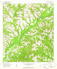 1960 Brundidge SE1963 Print · USGSCoffee County during the early sixties is captured here as a landscape of river-bottom farms and small rail stops. Genealogists can trace the rural communities of Tennille, Roeton, and Java alongside historic landmarks like Prestwood Millpond and New Tabernacle Ch.2 unique versions available
 - 1962 Map of Brundidge SE
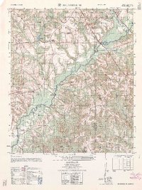 1962 Brundidge SE1962 Print · USGSCoffee and Dale counties in the early sixties reveal a landscape of river-bottom farms and emerging military installations. Genealogists can trace family roots through sites like Tennille, Roeton, and the Mt Olive Cemetery.
End of results
Showing maps 1-2 of 2
Top cities near Frisco
- Enterprise historical maps
- Troy historical maps
- Ozark historical maps
- Elba historical maps
- Brundidge historical maps
- New Brockton historical maps
See more
Frequently asked questions
- What are the different types of historical maps available for Frisco?
- What is the oldest map of Frisco?
- Where can I purchase historical maps of Frisco for my home or office?
- Where can I download high-res historical maps of Frisco?
- Are there historical topographic maps available for Frisco?
- Is there historical aerial imagery available for Frisco?
- Where are historical maps of Frisco sourced from?