2000-2009 Maps of Coosa County, Alabama
Explore 2 historic maps of Coosa County from 2000-2009. These maps offer a rare glimpse into what life looked like during the 2000s — showing old roads, neighborhoods, homes, and landmarks that have changed or disappeared over time.
Whether you're researching your family's past, planning a metal detecting trip, or studying how Coosa County's landscape evolved across the 2000s, these high-resolution maps are a powerful tool for exploring the history of this region.
- Focus on a specific era: All maps on this page are from the 2000s, giving you a focused view of this time period.
- See what’s changed: Compare century-old streets, trails, and buildings to today's modern landscape using overlays and satellite layers.
- Research with precision: Use these maps for genealogy, historical research, land use analysis, or educational projects.
- View, download, or print: Maps are fully viewable online in high resolution, and can be downloaded or printed for your own records.
Start exploring Coosa County's history through authentic maps from the 2000s. This is your window into the past.
Coosa County, AL maps
(2)- 2001 Map of Goodwater, 2004 Print
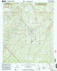 2001 Goodwater2004 Print · USGSThe crossroads and creeks of Coosa County come into focus in the early 2000s as the Central of Georgia railroad passes through Goodwater. Genealogists and local historians can trace family roots through rural landmarks like Smyrna Ch, Skeggs Crossroads, and Crestview Memorial Cem.
 - 2001 Map of Hollins, 2004 Print
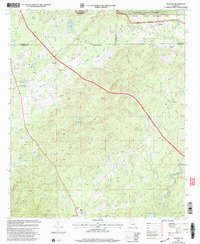 2001 Hollins2004 Print · USGSTalladega and Coosa counties met at the dawn of the millennium in this detailed study of the forest-heavy Alabama interior. Genealogists and local historians can trace rural community life through landmarks like Mt Pleasant Cem, Shiloh Ch, and the settlement of Hanover.
End of results
Showing maps 1-2 of 2
Top cities of Coosa County
- Stewartville historical maps
- Goodwater historical maps
- Rockford historical maps
- Nixburg historical maps
- Ray historical maps
- Mount Olive historical maps
See more
Frequently asked questions
- What are the different types of historical maps available for Coosa County?
- What is the oldest map of Coosa County?
- Where can I purchase historical maps of Coosa County for my home or office?
- Where can I download high-res historical maps of Coosa County?
- Are there historical topographic maps available for Coosa County?
- Is there historical aerial imagery available for Coosa County?
- Where are historical maps of Coosa County sourced from?