1900s (20th Century) Maps of Coosa County, Alabama
Explore 41 historic maps of Coosa County from the 1900s (20th Century). These maps offer a rare glimpse into what life looked like during the 1900s — showing old roads, neighborhoods, homes, and landmarks that have changed or disappeared over time.
Whether you're researching your family's past, planning a metal detecting trip, or studying how Coosa County's landscape evolved across the 1900s, these high-resolution maps are a powerful tool for exploring the history of this region.
- Focus on a specific era: All maps on this page are from the 1900s, giving you a focused view of this time period.
- See what’s changed: Compare century-old streets, trails, and buildings to today's modern landscape using overlays and satellite layers.
- Research with precision: Use these maps for genealogy, historical research, land use analysis, or educational projects.
- View, download, or print: Maps are fully viewable online in high resolution, and can be downloaded or printed for your own records.
Start exploring Coosa County's history through authentic maps from the 1900s. This is your window into the past.
Coosa County, AL maps
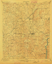
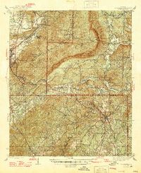
(41)- 1901 Map of Wetumpka
 1901 Wetumpka1901 Print · USGSCentral Alabama at the dawn of the twentieth century was a landscape of river ferries and emerging rail lines. Genealogists and local historians can trace family-named river crossings like Knights Ferry and Nobles Ferry or early community centers such as Nixburg and Eclectic.
 - 1903 Map of Wetumpka
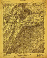
 1903 Wetumpka1903 Print · USGSCentral Alabama at the turn of the century remains a landscape of river ferries and emerging rail lines along the Coosa River. Genealogists and researchers can trace the early locations of Sykes Mills, Liberty Church, and river crossings like Nobles Ferry.3 unique versions available
 - 1906 Map of Dadeville
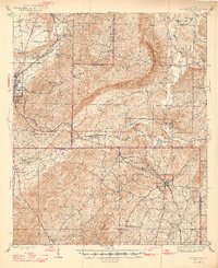
 1906 Dadeville1906 Print · USGSThe Tallapoosa River valley is shown at the turn of the century, defined by its numerous river ferries and a burgeoning rail network. Genealogists can trace family roots through rural landmarks like Rocky Ridge Church, Mc Ritchie Mill, and the many river crossings including McCarty Ferry.3 unique versions available
 - 1909 Map of Columbiana, 1968 Print
 1909 Columbiana1968 Print · USGSShelby County at the start of the twentieth century was a vital junction for the Southern and L&N railroads. Local researchers can locate family landmarks like Watson Ford, several rural schools including Summer Hill School, and early churches like Lyon Church.
 - 1911 Map of Columbiana
 1911 Columbiana1911 Print · USGSCentral Alabama's industrial landscape is captured here just after the first decade of the century, showing a region deeply connected by rail and river. Genealogists can trace family names at Woods Ferry or locate old community hubs like Summer Hill School and Kingdom Church.2 unique versions available
 - 1915 Map of Gantts Quarry
 1915 Gantts Quarry1915 Print · USGSTalladega and Shelby counties appear here during the height of the early twentieth-century marble boom. Researchers can trace the rail-driven economy near Sylacauga and locate family landmarks like Oak Grove Church, Gantts Quarry, and Center Hill School.4 unique versions available
 - 1917 Map of Gantts Quarry
 1917 Gantts Quarry1917 Print · USGSThe marble-rich corridor between the Coosa River and Sylacauga is captured here during the height of the early twentieth-century quarrying boom. Researchers can trace the rail-and-river economy through landmarks like Gantts Quarry, Mc Gowan Ferry, and Eureka Quarry.3 unique versions available
 - 1944 Map of Goodwater, 1947 Print
 1944 Goodwater1947 Print · USGSThe hill country of Coosa and Talladega counties is captured here just after the war, showing the railroad-industrial corridor from Sylacauga to Goodwater. Genealogists and historians can trace numerous rural sites like Trammells Sch, Haynes Chapel, and the remote Hollins Fire Tower.3 unique versions available
 - 1947 Map of Goodwater
 1947 Goodwater1947 Print · USGSCoosa and Talladega counties in the mid-1940s are shown as a network of rail-side towns and ridge-top lookouts. Genealogists and historians can locate rural landmarks like Hatchet Springs Sch, the Hollins Fire Tower, and the historic Wiregrass Road.2 unique versions available
 - 1953 Map of Montgomery, 1964 Print
 1953 Montgomery1964 Print · USGSCentral Alabama's river-and-rail corridor is mapped here in the mid-fifties, showing the vital connections between the capital and the Black Belt. Genealogists and historians can trace rail depots and crossroads from Marion Junction to Wetumpka, alongside landmarks like Craig AFB.4 unique versions available
 - 1953 Map of Birmingham, 1964 Print
 1953 Birmingham1964 Print · USGSCentral Alabama at mid-century shows a landscape defined by industrial expansion and the iron-rich ridges surrounding Birmingham. Researchers can trace the extensive rail networks of the L & N RR or locate historic federal sites like the Anniston Ordnance Depot.4 unique versions available
 - 1955 Map of Phenix City, 1964 Print
 1955 Phenix City1964 Print · USGSPost-war Alabama and Georgia meet along the Chattahoochee River as industry and military installations expand. Trace the rail lines of the Central of Georgia through towns like Opelika, Tuskegee, and Alexander City.3 unique versions available
 - 1956 Map of Birmingham
 1956 Birmingham1956 Print · USGSCentral Alabama in the mid-fifties exhibits a landscape of growing cities and deep-rooted industrial corridors. Genealogists and historians can trace the development of suburban Mountain Brook or locate regional hubs like Sylacauga and Jasper.
 - 1956 Map of Montgomery
 1956 Montgomery1956 Print · USGSCentral Alabama in the mid-1950s shows a landscape defined by its great river systems and a booming military aviation presence. Genealogists and historians can trace the rail corridors of the Southern Railway and locate tactical bases like Maxwell AFB and Craig AFB.
 - 1957 Map of Phenix City
 1957 Phenix City1957 Print · USGSThe Alabama-Georgia borderlands are captured here in the mid-fifties, centered on the bustling river crossing at Phenix City and Columbus. Researchers can trace the mid-century footprint of the Fort Benning Military Reservation or locate smaller textile and railroad towns like Langdale and Camp Hill.
 - 1957 Map of Birmingham
 1957 Birmingham1957 Print · USGSNorth-Central Alabama in the mid-fifties is an industrial powerhouse centered on the steel valleys and sprawling iron ridges. Genealogists and historians can trace the rail-linked growth of Birmingham and Tuscaloosa, or locate rural landmarks like Talladega College and the Anniston Ordnance Depot.
 - 1957 Map of Montgomery
 1957 Montgomery1957 Print · USGSCentral Alabama in the mid-fifties is defined by the winding Alabama River and a strategic network of military bases and rail lines. Trace family roots in Montgomery and Selma, or locate landmarks like Craig AFB and the State Capitol before the interstate era.
 - 1958 Map of Phenix City
 1958 Phenix City1958 Print · USGSThe Alabama-Georgia borderlands thrive during the late fifties, anchored by the river-driven industry of Columbus and Phenix City. Researchers can trace the mid-century footprints of Fort Benning, Auburn, and the textile towns of Fairfax and Lanett.
 - 1971 Map of Richville, 1973 Print
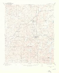
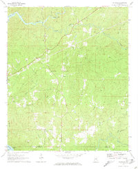 1971 Richville1973 Print · USGSCoosa County in the early seventies shows a landscape of rural crossroads and creek-fed valleys. Genealogists and local historians can trace family-named sites like Murchison Cem and the small settlements of Richville and Welona.2 unique versions available
 - 1971 Map of Mitchell Dam NW, 1973 Print
 1971 Mitchell Dam NW1973 Print · USGSThe Coosa River shoreline and the rural border of Chilton County appear here in the early seventies. Genealogists and local historians can locate early settlements like Quinsey and Dollar, or trace family sites such as Duke Cem and McSwain.
 - 1971 Map of Flag Mountain, 1973 Print
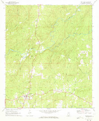
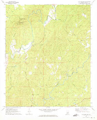 1971 Flag Mountain1973 Print · USGSCoosa County in the early seventies remains a landscape of high timbered ridges and winding creek bottoms. Genealogists can trace family footprints through rural centers like Moriah and Bentleyville or locate quiet landmarks like Old Union Cem and Tyler Ford.2 unique versions available
 - 1971 Map of Mitchell Dam, 1973 Print
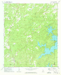
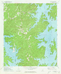
 1971 Mitchell Dam1973 Print · USGSThe Coosa River valley is captured here in the early seventies, dominated by the waters of Mitchell and Jordan Lakes. Researchers can trace rural life through landmarks like Corinth Ch, Williams Cem, and the massive hydroelectric works at Mitchell Dam.2 unique versions available
 - 1971 Map of Equality, 1973 Print
 1971 Equality1973 Print · USGSThe Coosa County hill country meets the rising waters of the Tallapoosa during the early 1970s. Genealogists can trace family landmarks like Nixburg Cem and Shiloh Cem or locate the site of the historic Covered Br on Oakachoy Creek.2 unique versions available
 - 1971 Map of Rockford, 1973 Print
 1971 Rockford1973 Print · USGSCoosa County was characterized by quiet rural life and creek-bottom timberlands in the early seventies. Genealogists and local historians can trace family ties at Miller-Patterson Cem and Rockford Ch, or locate the old High School in town.2 unique versions available
 - 1971 Map of Our Town, 1973 Print
 1971 Our Town1973 Print · USGSTallapoosa County and the winding shores of Martin Lake are captured here in the early seventies as recreation and local life converged. Genealogists can trace family names at Mt Zion Cem and Mask Cem or locate the rural settlement of Our Town.2 unique versions available
Showing maps 1-25 of 41
Top cities of Coosa County
- Stewartville historical maps
- Goodwater historical maps
- Rockford historical maps
- Nixburg historical maps
- Ray historical maps
- Mount Olive historical maps
See more
Frequently asked questions
- What are the different types of historical maps available for Coosa County?
- What is the oldest map of Coosa County?
- Where can I purchase historical maps of Coosa County for my home or office?
- Where can I download high-res historical maps of Coosa County?
- Are there historical topographic maps available for Coosa County?
- Is there historical aerial imagery available for Coosa County?
- Where are historical maps of Coosa County sourced from?