1970s Maps of Nixburg, Alabama
Explore 2 historic maps of Nixburg from the 1970s. These maps offer a rare glimpse into what life looked like during the 1970s — showing old roads, neighborhoods, homes, and landmarks that have changed or disappeared over time.
Whether you're researching your family's past, planning a metal detecting trip, or studying how Nixburg's landscape evolved across the 1970s, these high-resolution maps are a powerful tool for exploring the history of this region.
- Focus on a specific era: All maps on this page are from the 1970s, giving you a focused view of this time period.
- See what’s changed: Compare century-old streets, trails, and buildings to today's modern landscape using overlays and satellite layers.
- Research with precision: Use these maps for genealogy, historical research, land use analysis, or educational projects.
- View, download, or print: Maps are fully viewable online in high resolution, and can be downloaded or printed for your own records.
Start exploring Nixburg's history through authentic maps from the 1970s. This is your window into the past.
Nixburg, AL maps
(2)- 1971 Map of Equality, 1973 Print
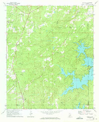 1971 Equality1973 Print · USGSThe Coosa County hill country meets the rising waters of the Tallapoosa during the early 1970s. Genealogists can trace family landmarks like Nixburg Cem and Shiloh Cem or locate the site of the historic Covered Br on Oakachoy Creek.2 unique versions available
 - 1971 Map of Kellyton, 1973 Print
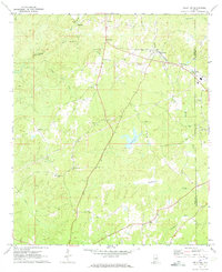 1971 Kellyton1973 Print · USGSCentral Alabama's rural landscape is captured here in the early seventies, centered on the railroad community of Kellyton. Local historians can trace family roots through numerous sites like Socapatoy Cem, Bradford Ch, and Jordan Cem.2 unique versions available
End of results
Showing maps 1-2 of 2
Top cities near Nixburg
- Alexander City historical maps
- Stewartville historical maps
- Goodwater historical maps
- Eclectic historical maps
- Our Town historical maps
- Hackneyville historical maps
See more
Frequently asked questions
- What are the different types of historical maps available for Nixburg?
- What is the oldest map of Nixburg?
- Where can I purchase historical maps of Nixburg for my home or office?
- Where can I download high-res historical maps of Nixburg?
- Are there historical topographic maps available for Nixburg?
- Is there historical aerial imagery available for Nixburg?
- Where are historical maps of Nixburg sourced from?