1980s Maps of Cahaba, Alabama
Explore 2 historic maps of Cahaba from the 1980s. These maps offer a rare glimpse into what life looked like during the 1980s — showing old roads, neighborhoods, homes, and landmarks that have changed or disappeared over time.
Whether you're researching your family's past, planning a metal detecting trip, or studying how Cahaba's landscape evolved across the 1980s, these high-resolution maps are a powerful tool for exploring the history of this region.
- Focus on a specific era: All maps on this page are from the 1980s, giving you a focused view of this time period.
- See what’s changed: Compare century-old streets, trails, and buildings to today's modern landscape using overlays and satellite layers.
- Research with precision: Use these maps for genealogy, historical research, land use analysis, or educational projects.
- View, download, or print: Maps are fully viewable online in high resolution, and can be downloaded or printed for your own records.
Start exploring Cahaba's history through authentic maps from the 1980s. This is your window into the past.
Cahaba, AL maps
(2)- 1986 Map of Selma
 1986 Selma1986 Print · USGSCentral Alabama's river and rail networks are preserved here in the mid-eighties, showing the transition from river travel to modern infrastructure. Researchers can trace the layout of Selma, the historic capital at Cahaba, and the Millers Ferry Lock and Dam.2 unique versions available
 - 1987 Map of Blackwell Bend
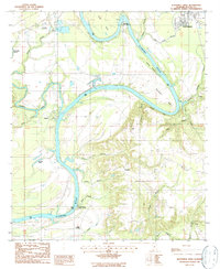 1987 Blackwell Bend1987 Print · USGSThe river bottomlands of Dallas County come into focus during the late 1980s, centered on the historic confluence of the Cahaba River and Alabama River. Researchers can trace the layout of West Selmont, locate small community landmarks like Mt Nebo, and identify river landings such as Kings Landing.
End of results
Showing maps 1-2 of 2
Top cities near Cahaba
Frequently asked questions
- What are the different types of historical maps available for Cahaba?
- What is the oldest map of Cahaba?
- Where can I purchase historical maps of Cahaba for my home or office?
- Where can I download high-res historical maps of Cahaba?
- Are there historical topographic maps available for Cahaba?
- Is there historical aerial imagery available for Cahaba?
- Where are historical maps of Cahaba sourced from?