1940s Maps of Rogers, Alabama
Explore 2 historic maps of Rogers from the 1940s. These maps offer a rare glimpse into what life looked like during the 1940s — showing old roads, neighborhoods, homes, and landmarks that have changed or disappeared over time.
Whether you're researching your family's past, planning a metal detecting trip, or studying how Rogers's landscape evolved across the 1940s, these high-resolution maps are a powerful tool for exploring the history of this region.
- Focus on a specific era: All maps on this page are from the 1940s, giving you a focused view of this time period.
- See what’s changed: Compare century-old streets, trails, and buildings to today's modern landscape using overlays and satellite layers.
- Research with precision: Use these maps for genealogy, historical research, land use analysis, or educational projects.
- View, download, or print: Maps are fully viewable online in high resolution, and can be downloaded or printed for your own records.
Start exploring Rogers's history through authentic maps from the 1940s. This is your window into the past.
Rogers, AL maps
(2)- 1946 Map of Sulphur Springs, 1956 Print
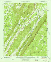 1946 Sulphur Springs1956 Print · USGSThe Alabama and Georgia state line meets along the spine of the mountains in this mid-century survey of the Little River Valley. Researchers can trace the path of the Southern Railroad through old stops like Sulphur Springs Station and find family landmarks like Pannell Cem and Amos Mill.3 unique versions available
 - 1947 Map of Sulphur Springs
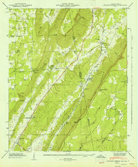 1947 Sulphur Springs1947 Print · USGSThe Alabama and Georgia state line divides this high-plateau landscape just after the war, showing a network of ridge-top settlements and valley rail stops. Researchers can locate family landmarks like Gann Crossroad, Amos Mill, and churches including Harmony Grove Ch and State Line Ch.2 unique versions available
End of results
Showing maps 1-2 of 2
Top cities near Rogers
- Fort Payne historical maps
- Rainsville historical maps
- Henagar historical maps
- Trenton historical maps
- Stevenson historical maps
- Sylvania historical maps
See more
Frequently asked questions
- What are the different types of historical maps available for Rogers?
- What is the oldest map of Rogers?
- Where can I purchase historical maps of Rogers for my home or office?
- Where can I download high-res historical maps of Rogers?
- Are there historical topographic maps available for Rogers?
- Is there historical aerial imagery available for Rogers?
- Where are historical maps of Rogers sourced from?