1900-1909 Maps of Seman, Alabama
Explore 3 historic maps of Seman from 1900-1909. These maps offer a rare glimpse into what life looked like during the 1900s — showing old roads, neighborhoods, homes, and landmarks that have changed or disappeared over time.
Whether you're researching your family's past, planning a metal detecting trip, or studying how Seman's landscape evolved across the 1900s, these high-resolution maps are a powerful tool for exploring the history of this region.
- Focus on a specific era: All maps on this page are from the 1900s, giving you a focused view of this time period.
- See what’s changed: Compare century-old streets, trails, and buildings to today's modern landscape using overlays and satellite layers.
- Research with precision: Use these maps for genealogy, historical research, land use analysis, or educational projects.
- View, download, or print: Maps are fully viewable online in high resolution, and can be downloaded or printed for your own records.
Start exploring Seman's history through authentic maps from the 1900s. This is your window into the past.
Seman, AL maps
(3)- 1901 Map of Wetumpka
 1901 Wetumpka1901 Print · USGSCentral Alabama at the dawn of the twentieth century was a landscape of river ferries and emerging rail lines. Genealogists and local historians can trace family-named river crossings like Knights Ferry and Nobles Ferry or early community centers such as Nixburg and Eclectic.
 - 1901 Map of Wetumpka
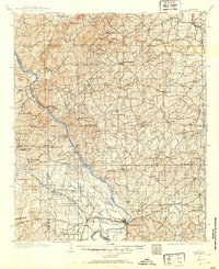 1901 Wetumpka1901 Print · USGSCentral Alabama at the turn of the century centers on the river junctions and early rail lines of Elmore and Coosa Counties. Trace the historical routes of the Louisville & Nashville RR and find long-forgotten sites like Sykes Mills and Liberty Church.
 - 1903 Map of Wetumpka
 1903 Wetumpka1903 Print · USGSCentral Alabama at the turn of the century remains a landscape of river ferries and emerging rail lines along the Coosa River. Genealogists and researchers can trace the early locations of Sykes Mills, Liberty Church, and river crossings like Nobles Ferry.3 unique versions available
End of results
Showing maps 1-3 of 3
Top cities near Seman
- Millbrook historical maps
- Alexander City historical maps
- Wetumpka historical maps
- Holtville historical maps
- Tallassee historical maps
- Elmore historical maps
See more
Frequently asked questions
- What are the different types of historical maps available for Seman?
- What is the oldest map of Seman?
- Where can I purchase historical maps of Seman for my home or office?
- Where can I download high-res historical maps of Seman?
- Are there historical topographic maps available for Seman?
- Is there historical aerial imagery available for Seman?
- Where are historical maps of Seman sourced from?