1980s Maps of Hale County, Alabama
Explore 14 historic maps of Hale County from the 1980s. These maps offer a rare glimpse into what life looked like during the 1980s — showing old roads, neighborhoods, homes, and landmarks that have changed or disappeared over time.
Whether you're researching your family's past, planning a metal detecting trip, or studying how Hale County's landscape evolved across the 1980s, these high-resolution maps are a powerful tool for exploring the history of this region.
- Focus on a specific era: All maps on this page are from the 1980s, giving you a focused view of this time period.
- See what’s changed: Compare century-old streets, trails, and buildings to today's modern landscape using overlays and satellite layers.
- Research with precision: Use these maps for genealogy, historical research, land use analysis, or educational projects.
- View, download, or print: Maps are fully viewable online in high resolution, and can be downloaded or printed for your own records.
Start exploring Hale County's history through authentic maps from the 1980s. This is your window into the past.
Hale County, AL maps
(14)- 1980 Map of Casemore
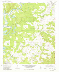
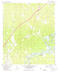
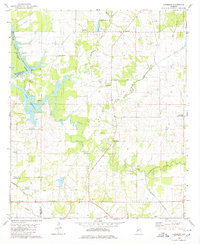 1980 Casemore1980 Print · USGSHale County's fertile Black Belt region is captured here in the 1980s, defined by the winding Black Warrior River and a dense network of rural communities. Researchers can trace local heritage through numerous landmarks like St Andrews Ch, Lock 5, and the old settlement of Prairieville.4 unique versions available
 - 1980 Map of Payne Lake
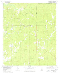
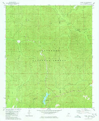 1980 Payne Lake1980 Print · USGSDeep in the Alabama woodlands during the 1980s, this area showcases the intersection of forest management and public recreation. Trace local history at Pine Flat Ch, the Old Railroad Grade, and the shores of Payne Lake.2 unique versions available
 - 1980 Map of Ingram
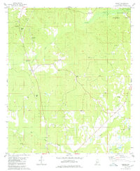 1980 Ingram1980 Print · USGSHale County's rural communities are meticulously documented in the late 1970s, showcasing a landscape of timber stands and historic congregations. Researchers can trace family roots at Puritt Spring Ch Cem, Holley Cem, and Rameys Chapel.2 unique versions available
 - 1980 Map of Newbern
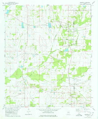 1980 Newbern1980 Print · USGSHale County, Alabama, is captured here in the mid-seventies, showing a landscape shaped by the SOUTHERN railroad and the waters of Big Prairie Creek. Genealogists can trace local roots through landmarks like Hatch Cem, Sunshine Sch, and Mars Hill Ch.
 - 1980 Map of Moundville West
 1980 Moundville West1980 Print · USGSThe Black Warrior River and Southern Railway define this Hale County landscape during the late twentieth century. Genealogists can trace family names at Taylor Chapel, Havana Cem, and small settlements like Powers and Guinea.
 - 1980 Map of Sawyerville
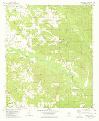 1980 Sawyerville1980 Print · USGSHale County settlement and transport patterns are captured here in the 1970s, from the rail hub of Akron to the rural roads of Sawyerville. Genealogists can trace family landmarks like Mays Cem, Hill Zion Ch, and several scattered Gravel Pits along Big Brush Creek.
 - 1980 Map of Hogglesville
 1980 Hogglesville1980 Print · USGSCentral Alabama at the start of the 1980s reveals a deeply rooted rural landscape where the Talladega National Forest meets active crossroads communities. Genealogists and historians can locate legacy sites like Old Shiloh Cem, Morgan Tabernacle, and the settlement of Hogglesville.2 unique versions available
 - 1980 Map of Warrior Dam
 1980 Warrior Dam1980 Print · USGSThe Black Warrior River winding through Greene and Hale Counties is shown here in the late seventies just as the modern lock system was well-established. Researchers can trace river landings and family sites like Finches Ferry, Wedgeworth, and Grimm Chapel.
 - 1980 Map of Knoxville
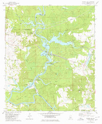
 1980 Knoxville1980 Print · USGSGreene and Hale counties meet along the winding river and lakefront during the early 1980s. Genealogists can trace family footprints through numerous rural churches like New Bethany Ch and the riverside settlement of Oak Village.
 - 1980 Map of Melton
 1980 Melton1980 Print · USGSHale County, Alabama, is documented here in the early eighties as the Black Warrior River floodplain meets the interior hills. Genealogists and historians can trace numerous rural burial grounds like Boston Cem and Ramey Cem or locate the State Penal Farm.2 unique versions available
 - 1980 Map of Moundville East
 1980 Moundville East1980 Print · USGSHale County settlement and the western fringes of the national forest are documented here during the early eighties. Researchers can trace rural lineages through numerous landmarks including Greenleaf Cem, Pleasant Hill Ch Cem, and Salem Ch.2 unique versions available
 - 1984 Map of Tuscaloosa, 1985 Print
 1984 Tuscaloosa1985 Print · USGSWest-central Alabama centers on the mid-1980s expansion of the university and the river economy. Genealogists and historians can trace small-town connections through Burchfield Store, North Johns, and the rail lines of the Southern railroad.2 unique versions available
 - 1986 Map of Selma
 1986 Selma1986 Print · USGSCentral Alabama's river and rail networks are preserved here in the mid-eighties, showing the transition from river travel to modern infrastructure. Researchers can trace the layout of Selma, the historic capital at Cahaba, and the Millers Ferry Lock and Dam.2 unique versions available
 - 1986 Map of Demopolis
 1986 Demopolis1986 Print · USGSWest-central Alabama's river-and-rail corridors are preserved here in the mid-eighties, showing the deep-seated settlement patterns of the Black Belt. Genealogists and historians can locate family-named landmarks like Crenshaw Quarters or industrial sites including Cleveland Mills and the Warrior Lock and Dam.
End of results
Showing maps 1-14 of 14
Top cities of Hale County
Frequently asked questions
- What are the different types of historical maps available for Hale County?
- What is the oldest map of Hale County?
- Where can I purchase historical maps of Hale County for my home or office?
- Where can I download high-res historical maps of Hale County?
- Are there historical topographic maps available for Hale County?
- Is there historical aerial imagery available for Hale County?
- Where are historical maps of Hale County sourced from?