1960s Maps of Hale County, Alabama
Explore 4 historic maps of Hale County from the 1960s. These maps offer a rare glimpse into what life looked like during the 1960s — showing old roads, neighborhoods, homes, and landmarks that have changed or disappeared over time.
Whether you're researching your family's past, planning a metal detecting trip, or studying how Hale County's landscape evolved across the 1960s, these high-resolution maps are a powerful tool for exploring the history of this region.
- Focus on a specific era: All maps on this page are from the 1960s, giving you a focused view of this time period.
- See what’s changed: Compare century-old streets, trails, and buildings to today's modern landscape using overlays and satellite layers.
- Research with precision: Use these maps for genealogy, historical research, land use analysis, or educational projects.
- View, download, or print: Maps are fully viewable online in high resolution, and can be downloaded or printed for your own records.
Start exploring Hale County's history through authentic maps from the 1960s. This is your window into the past.
Hale County, AL maps
(4)- 1968 Map of Uniontown West, 1971 Print
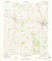 1968 Uniontown West1971 Print · USGSUniontown and Faunsdale sit at the center of this late-sixties survey of Alabama's Black Belt, following the route of the SOUTHERN railroad. Researchers can trace family history through local landmarks like St Michaels Cem, Siddonsville, and Hatch High Sch.3 unique versions available
 - 1968 Map of Gallion, 1971 Print
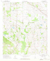 1968 Gallion1971 Print · USGSGallion and the surrounding Marengo County countryside appear here in the late sixties, showing a landscape defined by small rural congregations and the Southern railway. Researchers can trace family history through several landmarks like St Pauls Ch, St James Ch, and the Allenville Cem.3 unique versions available
 - 1969 Map of Duncanville, 1972 Print
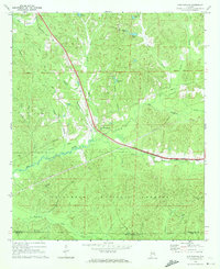 1969 Duncanville1972 Print · USGSDuncanville and the surrounding Tuscaloosa County hinterlands are shown here in the late sixties as the timber and rail industries shaped the local landscape. Genealogists can locate family landmarks like Mt Sinai Ch Cem, South Sandy Cem, and the Shiloh Lookout Tower.3 unique versions available
 - 1969 Map of Fosters, 1973 Print
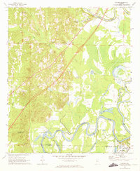 1969 Fosters1973 Print · USGSThe Black Warrior River valley near Tuscaloosa was undergoing major change in the late sixties as new highways were built through the bottomlands. Researchers can locate the Indian Mounds at Moundville or trace family sites like Myrtlewood Sch and Dry Creek Ch.2 unique versions available
End of results
Showing maps 1-4 of 4
Top cities of Hale County
Frequently asked questions
- What are the different types of historical maps available for Hale County?
- What is the oldest map of Hale County?
- Where can I purchase historical maps of Hale County for my home or office?
- Where can I download high-res historical maps of Hale County?
- Are there historical topographic maps available for Hale County?
- Is there historical aerial imagery available for Hale County?
- Where are historical maps of Hale County sourced from?